IMAGES TAKEN NEAR TO
Larg Road, STRANRAER, DG9 0JQ
Introduction
This page details the photographs taken nearby to Larg Road, DG9 0JQ by members of the Geograph project.
The Geograph project started in 2005 with the aim of publishing, organising and preserving representative images for every square kilometre of Great Britain, Ireland and the Isle of Man.

There are currently over 7.5m images from over14,400 individuals and you can help contribute to the project by visiting https://www.geograph.org.uk
Image Map
Images are licensed for reuse under creativecommons.org/licenses/by-sa/2.0
Notes
- Clicking on the map will re-center to the selected point.
- The higher the marker number, the further away the image location is from the centre of the postcode.
Image Listing (51 Images Found)
Images are licensed for reuse under creativecommons.org/licenses/by-sa/2.0
Image
Details
Distance
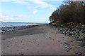
2
McCulloch's Point, Stranraer
Viewed from the end of Broadstone Road.
Image: © Oliver Dixon
Taken: 30 Apr 2006
0.06 miles
4
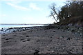
Shoreline at McCulloch's Point
Looking towards Stranraer in the distance.
Image: © Billy McCrorie
Taken: 27 Feb 2014
0.07 miles
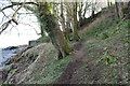
5
Path in the Woods at McCulloch's Point
Image: © Billy McCrorie
Taken: 27 Feb 2014
0.08 miles
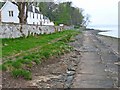
6
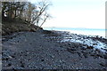
Shoreline at McCulloch's Point, Stranraer
Image: © Billy McCrorie
Taken: 27 Feb 2014
0.08 miles
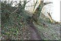
7
Path in the Woods at McCulloch's Point
Image: © Billy McCrorie
Taken: 27 Feb 2014
0.09 miles
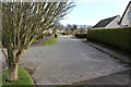
8

Footpath to Shore at Larg Road
Looking out over Loch Ryan.
Image: © Billy McCrorie
Taken: 27 Feb 2014
0.09 miles
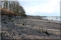
9
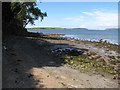
McCulloch's Point
A tree-fringed high tide mark with Loch Ryan and Ailsa Craig in the distance.
Image: © Jonathan Wilkins
Taken: 30 Jul 2012
0.09 miles