IMAGES TAKEN NEAR TO
Liddesdale Road, STRANRAER, DG9 0HW
Introduction
This page details the photographs taken nearby to Liddesdale Road, DG9 0HW by members of the Geograph project.
The Geograph project started in 2005 with the aim of publishing, organising and preserving representative images for every square kilometre of Great Britain, Ireland and the Isle of Man.

There are currently over 7.5m images from over14,400 individuals and you can help contribute to the project by visiting https://www.geograph.org.uk
Image Map
Images are licensed for reuse under creativecommons.org/licenses/by-sa/2.0
Notes
- Clicking on the map will re-center to the selected point.
- The higher the marker number, the further away the image location is from the centre of the postcode.
Image Listing (71 Images Found)
Images are licensed for reuse under creativecommons.org/licenses/by-sa/2.0
Image
Details
Distance
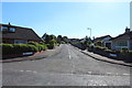
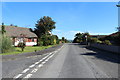
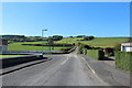
6
Leswalt High Road
At the junction with Seabank road.
Image: © Billy McCrorie
Taken: 11 Nov 2011
0.07 miles
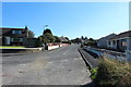
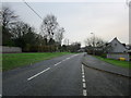
8
Spring Bank Road
From Leswalt High Road.
Image: © Billy McCrorie
Taken: 11 Nov 2011
0.08 miles
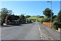
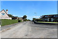
10
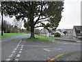
Large Tree
Tree at the junction of Seabank road and Leswalt High road.
Image: © Billy McCrorie
Taken: 11 Nov 2011
0.09 miles