IMAGES TAKEN NEAR TO
Dale Crescent, STRANRAER, DG9 0HQ
Introduction
This page details the photographs taken nearby to Dale Crescent, DG9 0HQ by members of the Geograph project.
The Geograph project started in 2005 with the aim of publishing, organising and preserving representative images for every square kilometre of Great Britain, Ireland and the Isle of Man.

There are currently over 7.5m images from over14,400 individuals and you can help contribute to the project by visiting https://www.geograph.org.uk
Image Map
Images are licensed for reuse under creativecommons.org/licenses/by-sa/2.0
Notes
- Clicking on the map will re-center to the selected point.
- The higher the marker number, the further away the image location is from the centre of the postcode.
Image Listing (91 Images Found)
Images are licensed for reuse under creativecommons.org/licenses/by-sa/2.0
Image
Details
Distance
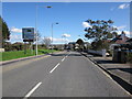
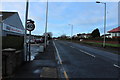
3
Leswalt Road
Looking NW along the A718, the main road from Stranraer to the west side of Loch Ryan. Note the milestone at the right, shown in better detail by Mary and Angus Hogg - Image - 2 miles to Leswalt.
Image: © M J Richardson
Taken: 14 Apr 2011
0.05 miles
4
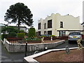
Glenotter, Leswalt Road
A smart looking B&B at the junction of Leswalt Road and Leswalt High Road.
Image: © M J Richardson
Taken: 14 Apr 2011
0.05 miles
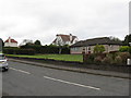
5

Window & Door Centre, Stranraer
On Leswalt High Road.
Image: © Billy McCrorie
Taken: 31 Dec 2013
0.05 miles
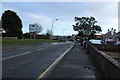
6
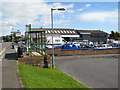
Business centre
Business premises and a bus stop on the Leswalt Road.
Image: © Jonathan Wilkins
Taken: 30 Jul 2012
0.05 miles
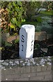
7
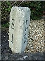
Old milestone
The well-painted and nicely set milestone at the edge of the garden on the A718 Leswalt Road in Stranraer. There is a bench mark on the flat top.
Image: © Chris Minto
Taken: 19 Apr 2023
0.05 miles
8
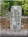
Old Milestone by the A718, Leswalt Road, Stranraer
Milestone by the A718, in parish of Leswalt (Wigtownshire District), Leswalt Road near lamppost LP55, at edge of house garden.
Inscription reads:-
: S / 1 : : L / 2 :
(To Stranraer and Leswalt)
Pivot benchmark on top.
Surveyed
Milestone Society National ID: DG_STLW01
Image: © Milestone Society
Taken: Unknown
0.05 miles
10
Mile Stone on Leswalt Road
The distances are 1 mile to Stranraer, 2 miles to Leswalt.
Image: © Mary and Angus Hogg
Taken: 13 Dec 2009
0.07 miles