IMAGES TAKEN NEAR TO
Port William, NEWTON STEWART, DG8 9JZ
Introduction
This page details the photographs taken nearby to DG8 9JZ by members of the Geograph project.
The Geograph project started in 2005 with the aim of publishing, organising and preserving representative images for every square kilometre of Great Britain, Ireland and the Isle of Man.

There are currently over 7.5m images from over14,400 individuals and you can help contribute to the project by visiting https://www.geograph.org.uk
Image Map (Loading...)


Getting Data...Please wait
Leaflet Map data © OpenStreetMap
Images are licensed for reuse under creativecommons.org/licenses/by-sa/2.0
Notes
- Clicking on the map will re-center to the selected point.
- The higher the marker number, the further away the image location is from the centre of the postcode.
Image Listing (18 Images Found)
Images are licensed for reuse under creativecommons.org/licenses/by-sa/2.0
Image
Details
Distance
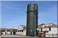
3
Dourie Pig High Health Unit
This is just outside Port William. The name of the place made me wonder if other pig farms are just Average Health Units.
Image: © David Medcalf
Taken: 15 Jul 2006
0.07 miles
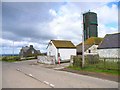
4
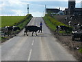
Rush Hour
Teatime Rush Hour ... Just outside Port William ... Held up in traffic again ... Cows in for milking at Dourie Farm ... Might be late home
Image: © Andy Farrington
Taken: 8 May 2010
0.10 miles
5

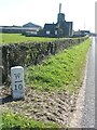
Old milestone
But it is one mile from the last milestone Wigtown 9/Port William 1!
Image: © Chris Minto
Taken: 20 Apr 2023
0.10 miles
6
Old milestone
All the milestones showing mileages from Wigtown to Port William on the A746 then B7085 are still by the roadside. This one almost at Port William is just west of Dourie.
Image: © Chris Minto
Taken: 20 Apr 2023
0.10 miles
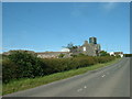
7
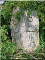
Old Milestone by the B7085, Dourie, Mochrum parish
Milestone by the B7085, in parish of Mochrum (Wigtownshire District), 150m from house, Dourie, on verge.
Inscription reads:-
: W / {arrow->} / 10 : : P / {<-arrow} / ½ :
(To Wigtown and Port William)
Surveyed
Milestone Society National ID: DG_WGPW10
Image: © Milestone Society
Taken: Unknown
0.11 miles
9
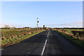
The B7085 to Whithorn
From Port William.
Image: © Billy McCrorie
Taken: 3 Jan 2020
0.18 miles
10
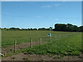
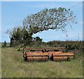
Farmland at Dourie
Looking south. The device in the field is a feeder, but for what? Probably sheep, seeing the trodden ground around it, but it's a bit small. Maybe it just dispenses 'supplements'.
Image: © David Medcalf
Taken: 15 Jul 2006
0.20 miles