
IMAGES TAKEN NEAR TO
Wigtown, NEWTON STEWART, DG8 9BH
Introduction
This page details the photographs taken nearby to DG8 9BH by members of the Geograph project.
The Geograph project started in 2005 with the aim of publishing, organising and preserving representative images for every square kilometre of Great Britain, Ireland and the Isle of Man.

There are currently over 7.5m images from over14,400 individuals and you can help contribute to the project by visiting https://www.geograph.org.uk
Image Map
Images are licensed for reuse under creativecommons.org/licenses/by-sa/2.0
Notes
- Clicking on the map will re-center to the selected point.
- The higher the marker number, the further away the image location is from the centre of the postcode.
Image Listing (10 Images Found)
Images are licensed for reuse under creativecommons.org/licenses/by-sa/2.0
Image
Details
Distance
1

Clusgston Cottage
At the side of the track to the farm.
Image: © Andy Farrington
Taken: 13 Jul 2012
0.01 miles
2

Clugston Farm
View from the track to the moors at the back of the farm.
Image: © Andy Farrington
Taken: 13 Jul 2012
0.06 miles
3
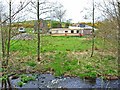
Travellers encampment at Clugston
What appears to be a traveller's encampment occupying a deserted farm, seen from the B7052 Whithorn to Kirkcowan road. Travellers seem to be particularly numerous in Wigtownshire.
Image: © Oliver Dixon
Taken: 1 May 2006
0.12 miles
5
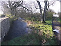
Spittal Croft
The track to the right leads to Spittal Croft. Clugston Burn, left of picture, passes under the B7052 at this point to join the River Bladnoch near Spittal.
Image: © Andy Farrington
Taken: 9 Nov 2010
0.20 miles
6

Track by Knocknacor Hill
Leads past the hill to Craigdow Moor.
Image: © Andy Farrington
Taken: 13 Jul 2012
0.20 miles
7
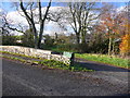
Spittal Croft
View of the entrance to the farm, with the statutory WW2 'ammo box' for post and messages.
Image: © Andy Farrington
Taken: 9 Nov 2010
0.21 miles
8

Small Lochan
At the side of a farm track to the east of Knocknacor Hill.
Image: © Andy Farrington
Taken: 13 Jul 2012
0.21 miles
9
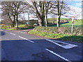
B7052 at Spittal Croft
View of this small road that eventually runs down to Sorbie. The single track road off to the right leads through Mindork Fell and Mark of Luce Moss to the A75.
Image: © Andy Farrington
Taken: 9 Nov 2010
0.22 miles
10
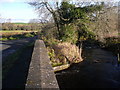
Clugston Burn
View of the burn as it passes underneath the B7052 and runs down to the River Bladnoch near Spittal.
Image: © Andy Farrington
Taken: 9 Nov 2010
0.24 miles