IMAGES TAKEN NEAR TO
Glasserton Street, NEWTON STEWART, DG8 8QQ
Introduction
This page details the photographs taken nearby to Glasserton Street, DG8 8QQ by members of the Geograph project.
The Geograph project started in 2005 with the aim of publishing, organising and preserving representative images for every square kilometre of Great Britain, Ireland and the Isle of Man.

There are currently over 7.5m images from over14,400 individuals and you can help contribute to the project by visiting https://www.geograph.org.uk
Image Map
Images are licensed for reuse under creativecommons.org/licenses/by-sa/2.0
Notes
- Clicking on the map will re-center to the selected point.
- The higher the marker number, the further away the image location is from the centre of the postcode.
Image Listing (90 Images Found)
Images are licensed for reuse under creativecommons.org/licenses/by-sa/2.0
Image
Details
Distance
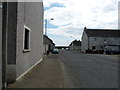
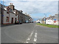
1

Isle Street, Whithorn
Approaching the junction with High Street.
Image: © Billy McCrorie
Taken: 4 Jun 2012
0.02 miles
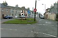
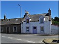
3
Glasserton Street
From the junction with Isle Street.
Image: © Billy McCrorie
Taken: 4 Jun 2012
0.02 miles

5
The B7004 leaving Whithorn
Here called Isle Street, it goes to Isle of Whithorn.
Image: © David Purchase
Taken: 27 Oct 2018
0.02 miles
6
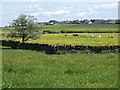
View from the New England Plantation
Looking across the fields to the top of Whithorn
Image: © Jon Alexander
Taken: 31 May 2016
0.03 miles
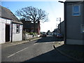
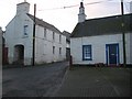
8
High Street, Whithorn
From the junction with Isle Street and Glasserton Street.
Image: © Billy McCrorie
Taken: 4 Jun 2012
0.03 miles
9
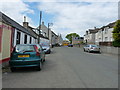
Isle Street, Whithorn
From the junction with Greencroft.
Image: © Billy McCrorie
Taken: 4 Jun 2012
0.04 miles
10
West Port, Whithorn
The wide high street in Whithorn narrows to pass through the West Port, actually at the southern end of town. A safe route for pedestrians exists under the building on the left.
Image: © Callum Black
Taken: 4 Jan 2007
0.06 miles