IMAGES TAKEN NEAR TO
Whithorn, NEWTON STEWART, DG8 8NQ
Introduction
This page details the photographs taken nearby to DG8 8NQ by members of the Geograph project.
The Geograph project started in 2005 with the aim of publishing, organising and preserving representative images for every square kilometre of Great Britain, Ireland and the Isle of Man.

There are currently over 7.5m images from over14,400 individuals and you can help contribute to the project by visiting https://www.geograph.org.uk
Image Map (Loading...)


Getting Data...Please wait
Leaflet Map data © OpenStreetMap
Images are licensed for reuse under creativecommons.org/licenses/by-sa/2.0
Notes
- Clicking on the map will re-center to the selected point.
- The higher the marker number, the further away the image location is from the centre of the postcode.
Image Listing (7 Images Found)
Images are licensed for reuse under creativecommons.org/licenses/by-sa/2.0
Image
Details
Distance
1
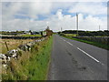
Monreith Animal World
View along the A747 past the Wildlife Park left of picture, as it is marked on OS Mapping, in the direction of the Isle of Whithorn.
Image: © Andy Farrington
Taken: 23 Sep 2010
0.01 miles
3

Old Milestone by the A747, Knock Farm Cottage, Glasserton Parish
By the A747, in parish of Glasserton (Wigtownshire District), opposite unoccupied bungalow, on verge.
Inscription reads:- : W (Whithorn) / {arrow} / 5 : : P (Port William) / {arrow} / 3 :
Surveyed
Milestone Society National ID: DG_WHPW05
Image: © Milestone Society
Taken: Unknown
0.11 miles
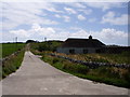
4
Knock Farm
View of the entrance road to the farm Geographed previously in 2007 Image
Image: © Andy Farrington
Taken: 23 Sep 2010
0.11 miles
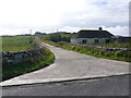
5
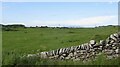
Low Knock
With Fell of Barhullion in the background.
Image: © Richard Webb
Taken: 15 Jun 2022
0.16 miles
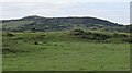
7
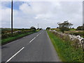
Garrarie
View along the A747 in the direction of Monreith.
Image: © Andy Farrington
Taken: 23 Sep 2010
0.25 miles