IMAGES TAKEN NEAR TO
Whithorn, NEWTON STEWART, DG8 8NE
Introduction
This page details the photographs taken nearby to DG8 8NE by members of the Geograph project.
The Geograph project started in 2005 with the aim of publishing, organising and preserving representative images for every square kilometre of Great Britain, Ireland and the Isle of Man.

There are currently over 7.5m images from over14,400 individuals and you can help contribute to the project by visiting https://www.geograph.org.uk
Image Map (Loading...)


Getting Data...Please wait
Leaflet Map data © OpenStreetMap
Images are licensed for reuse under creativecommons.org/licenses/by-sa/2.0
Notes
- Clicking on the map will re-center to the selected point.
- The higher the marker number, the further away the image location is from the centre of the postcode.
Image Listing (16 Images Found)
Images are licensed for reuse under creativecommons.org/licenses/by-sa/2.0
Image
Details
Distance
1
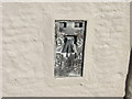
Ordnance Survey Flush Bracket S8118
This can be found on the wall of The Old School House at Craiglemine.
For more detail see : http://www.bench-marks.org.uk/bm2692
Image: © Peter Wood
Taken: 28 Sep 2013
0.01 miles
3
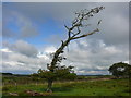
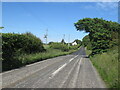
Prevailing Wind
Many trees in the Machars near the coastline demonstrate clearly which way the main winds blow. This tree is by the A747 near to Craiglemine Tigh and the view is across to the Galloway Hills.
Image: © Andy Farrington
Taken: 23 Sep 2010
0.05 miles
4
Milestone P5
View of this milestone marker on the A747 opposite Craiglemine Tigh B&B. P5 means Port William 5 miles that-a-way.
Image: © Andy Farrington
Taken: 23 Sep 2010
0.06 miles
5
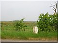
Old Milestone by the A747, Craiglemine, Glasserton Parish
By the A747, in parish of Glasserton (Wigtownshire District), near Craiglemine Tigh, dated 1847, on verge, North side of road.
Inscription reads:- : W / - / 3 : : P / - / 5 : (To Whitehorn and Port William)
Surveyed
Milestone Society National ID: DG_WHPW03.
Image: © Milestone Society
Taken: Unknown
0.06 miles
6
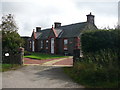
Craiglemine Tigh
View of this B&B on the A747 near Glasserton.
Image: © Andy Farrington
Taken: 23 Sep 2010
0.07 miles
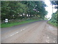
7
A747, Craiglemine
Passing an observatory making use of the dark skies and probable lower cloud incidence being on a low lying peninsula.
Image: © Richard Webb
Taken: 15 Jun 2022
0.07 miles
8
Craiglemine Telephone Box
This payphone does not get used too often (check out the height of the grass)
Image: © Mark McKie
Taken: 11 Aug 2007
0.09 miles
9
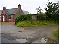
Craiglemine Cottage
View of the Galloway Astronomy Centre which is based at this cottage by the A747 near Glasserton http://www.gallowayastro.com/
Image: © Andy Farrington
Taken: 23 Sep 2010
0.09 miles
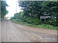
10
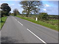
Craiglemine
View along the A747 in the direction of Port William, taken from this small road junction.
Image: © Andy Farrington
Taken: 23 Sep 2010
0.10 miles