IMAGES TAKEN NEAR TO
Whithorn, NEWTON STEWART, DG8 8JZ
Introduction
This page details the photographs taken nearby to DG8 8JZ by members of the Geograph project.
The Geograph project started in 2005 with the aim of publishing, organising and preserving representative images for every square kilometre of Great Britain, Ireland and the Isle of Man.

There are currently over 7.5m images from over14,400 individuals and you can help contribute to the project by visiting https://www.geograph.org.uk
Image Map
Images are licensed for reuse under creativecommons.org/licenses/by-sa/2.0
Notes
- Clicking on the map will re-center to the selected point.
- The higher the marker number, the further away the image location is from the centre of the postcode.
Image Listing (15 Images Found)
Images are licensed for reuse under creativecommons.org/licenses/by-sa/2.0
Image
Details
Distance
1
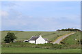
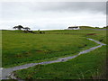
Prestrie Cottage
Road leading to the farm of Prestrie
Image: © Leslie Barrie
Taken: 17 Jun 2014
0.00 miles
3
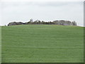
B7004
View across open farmland towards Prestrie Farm.
Image: © Andy Farrington
Taken: 16 Nov 2010
0.08 miles
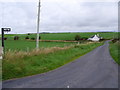
4
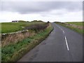
B7004 to Whithorn
View of this road past Doon Cottage left of picture.
Image: © Andy Farrington
Taken: 16 Nov 2010
0.10 miles
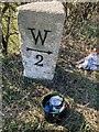
5

Old Milestone by the B7004, Whithorn parish
Stone post by the B7004, in parish of Whithorn (Wigtownshire District), in open country, on verge, South side of road.
Inscription reads:-
: W / {arrow->} / 2 : : I / {<-arrow} / 1 :
(To Whithorn and Isle of Whithorn)
Surveyed
Milestone Society National ID: DG_WHIW02
Image: © Milestone Society
Taken: Unknown
0.14 miles
6
Old milestone
On the south side of the B7004 between Isle of Whithorn and Whithorn on the A740 is a Wigtownshire quadrant milestone. The vegetation has been cleared with the legend having a coat of black paint. The W is for Whithorn.
Image: © Jacqueline Crowther
Taken: 23 Mar 2022
0.14 miles
7
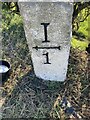
Old milestone
The right face of the Isle of Whithorn to Whithorn milestone in open country on the B7004 having its legends repainted and vegetation cleared from around it.
Image: © Jacqueline Crowther
Taken: 23 Mar 2022
0.14 miles
8
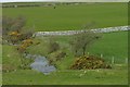
Burn by the B7004
View of this burn at the side of the B7004 which originates near to High Arrow and flows under the road to join Drummullin Burn. Doon Cottage and Doon of Arbrack Quarry are on the horizon.
Image: © Andy Farrington
Taken: 16 Nov 2010
0.15 miles