IMAGES TAKEN NEAR TO
Whithorn, NEWTON STEWART, DG8 8HR
Introduction
This page details the photographs taken nearby to DG8 8HR by members of the Geograph project.
The Geograph project started in 2005 with the aim of publishing, organising and preserving representative images for every square kilometre of Great Britain, Ireland and the Isle of Man.

There are currently over 7.5m images from over14,400 individuals and you can help contribute to the project by visiting https://www.geograph.org.uk
Image Map
Images are licensed for reuse under creativecommons.org/licenses/by-sa/2.0
Notes
- Clicking on the map will re-center to the selected point.
- The higher the marker number, the further away the image location is from the centre of the postcode.
Image Listing (8 Images Found)
Images are licensed for reuse under creativecommons.org/licenses/by-sa/2.0
Image
Details
Distance
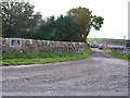
2
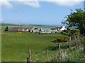
Low Skeog Farm
View from the side of the farm
Image: © Andy Farrington
Taken: 18 May 2010
0.12 miles
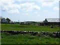
3
Low Skeog
Looking to the rear of the farm, a second large building has been added since 2010 when Andy Farrington took his picture of Image Ket Burn is on the right, making its way to Port Yerrock.
Image: © Jon Alexander
Taken: 22 Jan 2019
0.13 miles
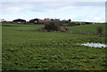
4
Farm Buildings
Seen at the side of the track to Drummaston Farm.
Image: © Andy Farrington
Taken: 18 May 2010
0.15 miles
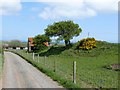
5
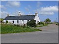
Low Skeog Cottage
View from the B7063 leading to Whithorn
Image: © Andy Farrington
Taken: 18 May 2010
0.15 miles
6
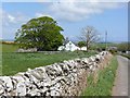
Drummaston Farm
Track leading past the farm
Image: © Andy Farrington
Taken: 18 May 2010
0.17 miles
7
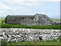
Auldbreck Farm
Derelict building at the farm
Image: © Andy Farrington
Taken: 18 May 2010
0.21 miles
8
Auldbreck Farm
Side view of the farm
Image: © Andy Farrington
Taken: 18 May 2010
0.24 miles