IMAGES TAKEN NEAR TO
Garlieston, NEWTON STEWART, DG8 8BT
Introduction
This page details the photographs taken nearby to DG8 8BT by members of the Geograph project.
The Geograph project started in 2005 with the aim of publishing, organising and preserving representative images for every square kilometre of Great Britain, Ireland and the Isle of Man.

There are currently over 7.5m images from over14,400 individuals and you can help contribute to the project by visiting https://www.geograph.org.uk
Image Map
Images are licensed for reuse under creativecommons.org/licenses/by-sa/2.0
Notes
- Clicking on the map will re-center to the selected point.
- The higher the marker number, the further away the image location is from the centre of the postcode.
Image Listing (308 Images Found)
Images are licensed for reuse under creativecommons.org/licenses/by-sa/2.0
Image
Details
Distance
1
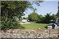
Part of the campsite
This is the last section the railway ran before reaching the harbour. The road you see in the distance was certainly the trackbed once though it may have finished in a goods yard at the end by the road.
Image: © Bill Nicholls
Taken: 28 May 2012
0.03 miles
2
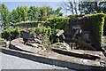
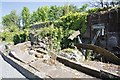
Old Mill at the Campsite
These remains are on the Campsite off Burnside in Garlieston, they are of an old sawmill which served the estate it was on. The wheel is still there though fallen apart and the overflow from the mill can be seen.
Image: © Bill Nicholls
Taken: 27 May 2012
0.03 miles
3
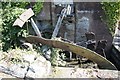
Remains of the Mill
Some of the water wheel remains from the old wood mill at the campsite of Burnside in Garlieston.
Image: © Bill Nicholls
Taken: 27 May 2012
0.03 miles
4
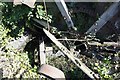
In the wheel pit
View of the remains of the water wheel in the pit from the old wood mill. Looks to me like it could be restored quite easily.
Image: © Bill Nicholls
Taken: 27 May 2012
0.03 miles
5
Overflow from the mill
I presume this is where the water ran when the wheel was not in use, diverted round and back in the outfall.
Image: © Bill Nicholls
Taken: 27 May 2012
0.03 miles
6
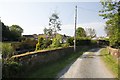
Crossing by the gate
This road lead to the old estate sawmill with local level crossing that crossed the railway that went through here, the section of wall just past the post is about where it went. The gates now are part of a camp site which is behind me.
Image: © Bill Nicholls
Taken: 28 May 2012
0.04 miles
7
Burnside Lane
Named after the stream which runs nearby in Garlieston
Image: © Bill Nicholls
Taken: 27 May 2012
0.04 miles
8
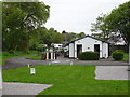
Garliestown 2nd station (site), Dumfries & Galloway
Opened in 1876 by Directors of the Wigtown Railway on what later became the Portpatrick & Wigtownshire Joint Railway, this station was on a short branch line off the P&WJR branch line from Newton Stewart to Whithorn. It replaced Image but closed to regular passenger traffic as early as 1903 and to occasional excursions in 1935.
View north west along the former platform. The only remainder is the short section of grey wall to the left of the white facilities block, which carried the platform edge. The platform was on a curve, which can still be identified looking towards the camper vans in the distance.
Image: © Nigel Thompson
Taken: 8 May 2019
0.06 miles
9
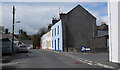
Houses at the edge of Garlieston village
The woods of Millhill Plantation lie beyond the end of the street where a path leads leftwards to the Home Farm of Galloway House.
Image: © Anthony O'Neil
Taken: 18 Apr 2010
0.06 miles
10
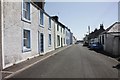
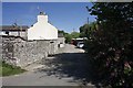
South Street
View along South Street Garlieston looking towards the sea front.
Image: © Bill Nicholls
Taken: 27 May 2012
0.07 miles