IMAGES TAKEN NEAR TO
NEWTON STEWART, DG8 7AD
Introduction
This page details the photographs taken nearby to DG8 7AD by members of the Geograph project.
The Geograph project started in 2005 with the aim of publishing, organising and preserving representative images for every square kilometre of Great Britain, Ireland and the Isle of Man.

There are currently over 7.5m images from over14,400 individuals and you can help contribute to the project by visiting https://www.geograph.org.uk
Image Map
Images are licensed for reuse under creativecommons.org/licenses/by-sa/2.0
Notes
- Clicking on the map will re-center to the selected point.
- The higher the marker number, the further away the image location is from the centre of the postcode.
Image Listing (5 Images Found)
Images are licensed for reuse under creativecommons.org/licenses/by-sa/2.0
Image
Details
Distance
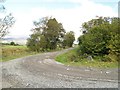
3
Looking along the track to Risk Farm
From the junction with the lane.
Image: © Andrew Hill
Taken: 14 Apr 2009
0.09 miles
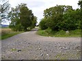
4
Old Edinburgh road
The old Edinburgh road runs up the side of this field
Image: © Mark McKie
Taken: 15 Jul 2007
0.19 miles
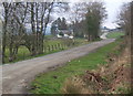
5

Snow on the Risk Road
Cairnsmore of Fleet with a cap of cloud, just left of centre.
Image: © David Baird
Taken: 16 Dec 2011
0.21 miles