IMAGES TAKEN NEAR TO
NEWTON STEWART, DG8 6SW
Introduction
This page details the photographs taken nearby to DG8 6SW by members of the Geograph project.
The Geograph project started in 2005 with the aim of publishing, organising and preserving representative images for every square kilometre of Great Britain, Ireland and the Isle of Man.

There are currently over 7.5m images from over14,400 individuals and you can help contribute to the project by visiting https://www.geograph.org.uk
Image Map (Loading...)


Getting Data...Please wait
Leaflet Map data © OpenStreetMap
Images are licensed for reuse under creativecommons.org/licenses/by-sa/2.0
Notes
- Clicking on the map will re-center to the selected point.
- The higher the marker number, the further away the image location is from the centre of the postcode.
Image Listing (17 Images Found)
Images are licensed for reuse under creativecommons.org/licenses/by-sa/2.0
Image
Details
Distance
1

Drannandow Farm
Newton Stewart, Galloway
Image: © Anthony O'Neil
Taken: 14 Aug 2016
0.13 miles
3
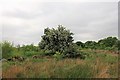
Hawthorn by Plantation
A Hawthorn amongst a small plantation at the edge of Cree Wood.
Image: © Andrew Wood
Taken: 24 May 2017
0.17 miles
4
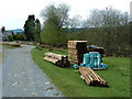
New fencing materials waiting at Drannandow Farm
Farmhouse at the extreme left.
Image: © Anthony O'Neil
Taken: 2 May 2012
0.19 miles
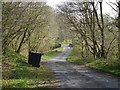
5
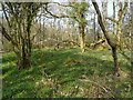
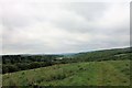
Wood of Cree
Woodland in the care of the RSPB.
Image: © Richard Webb
Taken: 20 Apr 2019
0.20 miles
6
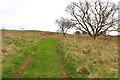
Hill Top Track
A track left in grassland above Cree Wood.
Image: © Andrew Wood
Taken: 24 May 2017
0.20 miles
7
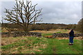
Walker on Mill Hill Trail near Barclye
Image: © Billy McCrorie
Taken: 9 Apr 2014
0.20 miles
9
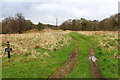
Track to Cree Wood
Mill hill trail on the left.
Image: © Billy McCrorie
Taken: 9 Apr 2014
0.22 miles
10
Cruive End Bridge
On the minor road north of Minnigaff.
Image: © Richard Webb
Taken: 20 Apr 2019
0.23 miles