IMAGES TAKEN NEAR TO
Old Station Court, NEWTON STEWART, DG8 6QY
Introduction
This page details the photographs taken nearby to Old Station Court, DG8 6QY by members of the Geograph project.
The Geograph project started in 2005 with the aim of publishing, organising and preserving representative images for every square kilometre of Great Britain, Ireland and the Isle of Man.

There are currently over 7.5m images from over14,400 individuals and you can help contribute to the project by visiting https://www.geograph.org.uk
Image Map (Loading...)


Getting Data...Please wait
Leaflet Map data © OpenStreetMap
Images are licensed for reuse under creativecommons.org/licenses/by-sa/2.0
Notes
- Clicking on the map will re-center to the selected point.
- The higher the marker number, the further away the image location is from the centre of the postcode.
Image Listing (233 Images Found)
Images are licensed for reuse under creativecommons.org/licenses/by-sa/2.0
Image
Details
Distance
4
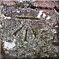
Cut Mark: Newton Stewart, Princes Street, Bridge
Cut mark on the west parapet of the bridge carrying Princes Street over the former railway route, now a Royal Mail depot. See http://www.geograph.org.uk/photo/5731139 for a wider view and http://www.bench-marks.org.uk/bm94361 for details.
Image: © Brian Westlake
Taken: 25 Mar 2018
0.04 miles
5
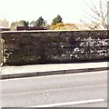
Cut Mark: Newton Stewart, Princes Street, Bridge
There is a cut mark on the west parapet of the bridge carrying Princes Street over the former railway route, now a Royal Mail depot. See http://www.geograph.org.uk/photo/5731132 for a closer view and http://www.bench-marks.org.uk/bm94361 for details.
Image: © Brian Westlake
Taken: 25 Mar 2018
0.04 miles
8
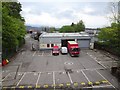
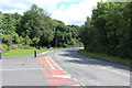
Newton Stewart railway station (site), Dumfries & Galloway
Opened in 1861 by the Portpatrick Railway on what later became the Portpatrick & Wigtownshire Joint Railway from Castle Douglas to Portpatrick, this station closed in 1965. The railway line was known as the 'Port Road'.
View east towards Palnure and Castle Douglas. The line went under the camera position - the bridge was still in situ when this image was taken. Behind the camera the line split, with a branch line to Whithorn curving south away from the main line to Stranraer and Portpatrick.
Image: © Nigel Thompson
Taken: 8 May 2019
0.06 miles