IMAGES TAKEN NEAR TO
NEWTON STEWART, DG8 6QW
Introduction
This page details the photographs taken nearby to DG8 6QW by members of the Geograph project.
The Geograph project started in 2005 with the aim of publishing, organising and preserving representative images for every square kilometre of Great Britain, Ireland and the Isle of Man.

There are currently over 7.5m images from over14,400 individuals and you can help contribute to the project by visiting https://www.geograph.org.uk
Image Map (Loading...)


Getting Data...Please wait
Leaflet Map data © OpenStreetMap
Images are licensed for reuse under creativecommons.org/licenses/by-sa/2.0
Notes
- Clicking on the map will re-center to the selected point.
- The higher the marker number, the further away the image location is from the centre of the postcode.
Image Listing (16 Images Found)
Images are licensed for reuse under creativecommons.org/licenses/by-sa/2.0
Image
Details
Distance
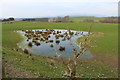
1
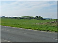
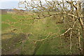
West Knockbrex
Farmland next to the A75.
Image: © Billy McCrorie
Taken: 28 May 2012
0.02 miles
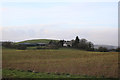
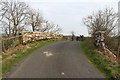
3
Route of the Old Railway Line to Newton Stewart
Next West Knockbrex.
Image: © Billy McCrorie
Taken: 31 Mar 2014
0.16 miles
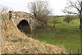
4
Bridge over dismantled Railway near West Knockbrex
Image: © Billy McCrorie
Taken: 31 Mar 2014
0.18 miles
5
Bridge over dismantled Railway near West Knockbrex
Image: © Billy McCrorie
Taken: 31 Mar 2014
0.18 miles
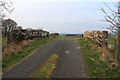
7
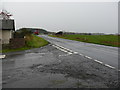
Knockbrex Toll
View along the A75 in the direction of Stranraer. A wet and windy day.
Image: © Andy Farrington
Taken: 4 Nov 2010
0.19 miles
9
Route of the Old Railway Line to Newton Stewart
Image: © Billy McCrorie
Taken: 31 Mar 2014
0.19 miles
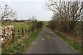
10

West Knockbrex Bridge
The Bridge runs over the old railway line
Image: © Mark McKie
Taken: 14 Sep 2007
0.20 miles