IMAGES TAKEN NEAR TO
Holmpark Drive, NEWTON STEWART, DG8 6QT
Introduction
This page details the photographs taken nearby to Holmpark Drive, DG8 6QT by members of the Geograph project.
The Geograph project started in 2005 with the aim of publishing, organising and preserving representative images for every square kilometre of Great Britain, Ireland and the Isle of Man.

There are currently over 7.5m images from over14,400 individuals and you can help contribute to the project by visiting https://www.geograph.org.uk
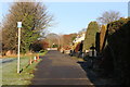
Image Map (Loading...)


Getting Data...Please wait
Leaflet Map data © OpenStreetMap
Images are licensed for reuse under creativecommons.org/licenses/by-sa/2.0
Notes
- Clicking on the map will re-center to the selected point.
- The higher the marker number, the further away the image location is from the centre of the postcode.
Image Listing (764 Images Found)
Images are licensed for reuse under creativecommons.org/licenses/by-sa/2.0
Image
Details
Distance
1

Minnigaff Village
Across the Cree from Newton Stewart.
Image: © Billy McCrorie
Taken: 31 Dec 2019
0.07 miles
2

Eastern bank of the Cree in Newton Stewart
Recently cleared of much overgrown vegetation to provide clear views down the river.
Image: © Anthony O'Neil
Taken: 11 Apr 2011
0.11 miles
4

Blue Hydrangea
Riverside garden - Newton Stewart
Image: © Anthony O'Neil
Taken: 21 Oct 2009
0.12 miles
5

White Hydrangea
Beside the River Cree, Newton Stewart
Image: © Anthony O'Neil
Taken: 21 Oct 2009
0.12 miles
6
Footpath to Creebridge
Probably not in the top ten walks to do in Newton Stewart past the Sewage Pumping Station but it is the shortest route from town to Creebridge, needs must.
Image: © Andy Farrington
Taken: 31 Mar 2012
0.12 miles
7

Marital Harmony
Mr & Mrs Mallard walk in step on an excursion from the nearby River Cree. Ducks and other waterfowl are frequent visitors to the gardens of adjacent houses on the edge of Newton Stewart.
Image: © Anthony O'Neil
Taken: 11 Apr 2011
0.12 miles
8
Camp site, Creebridge
Remaining buildings and the road layout suggest that this was a c. World War II establishment. A quick check revealed that it is the site of a prisoner of war camp, mainly used to house Italians. Judging by my grandparent's accounts of Italian PoWs they would have worked on local farms and forests and some of their descendants will probably still be in the area. I wonder what it was used for in post war years? I bet forestry was involved. (Anyway I have not tagged this as a PoW camp, as it may give a misleading impression of my experiences staying here).
The campsite is a very good one and had up to date facilities. My corner paddock was very rich in wildlife and gave an experience akin to sleeping in a native woodland. Lovely friendly place.
Image: © Richard Webb
Taken: 21 Apr 2019
0.12 miles
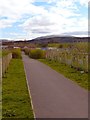
10
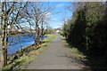
Newton Stewart Local Walks beside the Cree
This is the path for walks 3,4, and 7.
Image: © Billy McCrorie
Taken: 24 Mar 2014
0.12 miles