IMAGES TAKEN NEAR TO
St. Couans Place, NEWTON STEWART, DG8 6LY
Introduction
This page details the photographs taken nearby to St. Couans Place, DG8 6LY by members of the Geograph project.
The Geograph project started in 2005 with the aim of publishing, organising and preserving representative images for every square kilometre of Great Britain, Ireland and the Isle of Man.

There are currently over 7.5m images from over14,400 individuals and you can help contribute to the project by visiting https://www.geograph.org.uk
Image Map
Images are licensed for reuse under creativecommons.org/licenses/by-sa/2.0
Notes
- Clicking on the map will re-center to the selected point.
- The higher the marker number, the further away the image location is from the centre of the postcode.
Image Listing (166 Images Found)
Images are licensed for reuse under creativecommons.org/licenses/by-sa/2.0
Image
Details
Distance
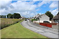
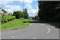
6
Georgewell Drive, Newton Stewart
The road on the far right is the A75.
Image: © Billy McCrorie
Taken: 21 Jul 2016
0.06 miles
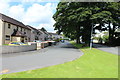
9
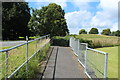
Footpath to Newton Stewart Hospital
Crossing the A75.
Image: © Billy McCrorie
Taken: 21 Jul 2016
0.07 miles