IMAGES TAKEN NEAR TO
Allanfield Place, NEWTON STEWART, DG8 6BS
Introduction
This page details the photographs taken nearby to Allanfield Place, DG8 6BS by members of the Geograph project.
The Geograph project started in 2005 with the aim of publishing, organising and preserving representative images for every square kilometre of Great Britain, Ireland and the Isle of Man.

There are currently over 7.5m images from over14,400 individuals and you can help contribute to the project by visiting https://www.geograph.org.uk
Image Map
Images are licensed for reuse under creativecommons.org/licenses/by-sa/2.0
Notes
- Clicking on the map will re-center to the selected point.
- The higher the marker number, the further away the image location is from the centre of the postcode.
Image Listing (221 Images Found)
Images are licensed for reuse under creativecommons.org/licenses/by-sa/2.0
Image
Details
Distance
1
Allenfield Drive
From Corvisel Road.
Image: © Billy McCrorie
Taken: 28 May 2012
0.04 miles
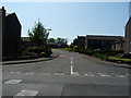
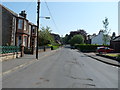
2

Corvisel Road
Heading for Princes Street.
Image: © Billy McCrorie
Taken: 28 May 2012
0.05 miles
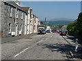
3
Corvisel Road
From the junction with Princes Street.
Image: © Billy McCrorie
Taken: 28 May 2012
0.06 miles
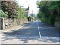
4
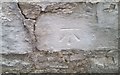
Ordnance Survey Cut Mark
This OS cut mark can be found on the SE side of Princess Street. It marks a point 29.436m above mean sea level.
Image: © Adrian Dust
Taken: 23 Mar 2018
0.06 miles
5
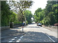
Princes Street
From the junction with Corvisel Road.
Image: © Billy McCrorie
Taken: 28 May 2012
0.06 miles
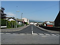
6
Corvisel Road
In the direction of Station Road.
Image: © Billy McCrorie
Taken: 28 May 2012
0.07 miles
7
Mansfield Place
From the junction with Corvisel Road.
Image: © Billy McCrorie
Taken: 28 May 2012
0.09 miles
8
Princes Street
From the junction with Corvisel Road going back towards the town centre.
Image: © Billy McCrorie
Taken: 28 May 2012
0.09 miles
9

Old Milestone by Station Yard, Newton Stewart, Penninghame Parish
By the UC road, plate lost, in parish of Penninghame (Wigtownshire District), Newton Stewart, in Station Yard cul-de-sac, formerly main road, opposite 'Torlundy'.
Inscription once read:- : (Newton Stewart / 1 Mile) :
Carved bench mark on top.
Surveyed
Milestone Society National ID: DG_NSGL01
Image: © Milestone Society
Taken: Unknown
0.10 miles