IMAGES TAKEN NEAR TO
NEWTON STEWART, DG8 6BQ
Introduction
This page details the photographs taken nearby to DG8 6BQ by members of the Geograph project.
The Geograph project started in 2005 with the aim of publishing, organising and preserving representative images for every square kilometre of Great Britain, Ireland and the Isle of Man.

There are currently over 7.5m images from over14,400 individuals and you can help contribute to the project by visiting https://www.geograph.org.uk
Image Map
Images are licensed for reuse under creativecommons.org/licenses/by-sa/2.0
Notes
- Clicking on the map will re-center to the selected point.
- The higher the marker number, the further away the image location is from the centre of the postcode.
Image Listing (6 Images Found)
Images are licensed for reuse under creativecommons.org/licenses/by-sa/2.0
Image
Details
Distance
1
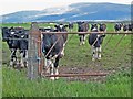
Cattle beside the A714
Seen from the Newton Stewart to Wigtown road. Cairnsmore of Fleet Image in the distance.
Image: © Oliver Dixon
Taken: 8 May 2007
0.09 miles
2
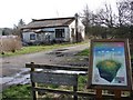
Carsegowan Moss
Carsegowan Moss is a Scottish Wildlife Trust site. ICI Nobel built an explosives factory here in WW2 producing gunpowder; it closed in 1945-6 but many buildings remain - for example this cottage was a gatehouse or guardhouse; workers passed through a gate on the right of the building, showing their passes at the window.
Image: © Chris Newman
Taken: 14 Mar 2007
0.12 miles
3
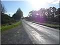
Causeway End Bridge
View along the A714 south over the bridge in the direction of Wigtown.
Image: © Andy Farrington
Taken: 20 Oct 2010
0.15 miles
4
Carsegowan Moss Munitions Factory
View over to the site of this former WW2 munitions factory. Currently the factory canteen is for sale and a planning application has been made for change of use and conversion to a residential dwelling. Other buildings are also available by separate negotiation, however the estate agents details has a warning (in bold letters!) that anyone wishing to view any of these premises should do so at their own risk.
Image: © Andy Farrington
Taken: 20 Oct 2010
0.17 miles
5
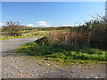
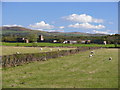
Carsegowan Moss
Entrance road to Claymore and Carsegowan Moss, a nature reserve managed by the Scottish Wildlife Trust. Carsegowan Munitions Factory is in the background Image
Image: © Andy Farrington
Taken: 20 Oct 2010
0.19 miles
6
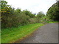
Causewayend railway station (site), Dumfries & Galloway
Opened in 1875 by the Wigtown Railway on what later became the Portpatrick & Wigtownshire Joint Railway branch line from Newton Stewart to Whithorn, this short-lived station closed in 1885.
View north west from the road. The line was behind the gate, and appears to be used as a farm track. Running to the left it entered a short cutting to go under the road on the way to Wigtown and Whithorn. The platform must have been somewhere near the gate but no maps are known to exist showing the exact location.
Image: © Nigel Thompson
Taken: 8 May 2019
0.21 miles