IMAGES TAKEN NEAR TO
NEWTON STEWART, DG8 6AU
Introduction
This page details the photographs taken nearby to DG8 6AU by members of the Geograph project.
The Geograph project started in 2005 with the aim of publishing, organising and preserving representative images for every square kilometre of Great Britain, Ireland and the Isle of Man.

There are currently over 7.5m images from over14,400 individuals and you can help contribute to the project by visiting https://www.geograph.org.uk
Image Map (Loading...)


Getting Data...Please wait
Leaflet Map data © OpenStreetMap
Images are licensed for reuse under creativecommons.org/licenses/by-sa/2.0
Notes
- Clicking on the map will re-center to the selected point.
- The higher the marker number, the further away the image location is from the centre of the postcode.
Image Listing (15 Images Found)
Images are licensed for reuse under creativecommons.org/licenses/by-sa/2.0
Image
Details
Distance
1
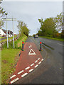
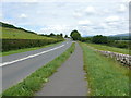
Cycle path beside the A714
National Cycle Network 73 runs round the south-west of Scotland. South of Newton Stewart, it follows the A714 for about 2 km. To keep cyclists off the main road, a separate cycle path has been constructed; south of Nether Barr, this path is immediately adjacent to the roadway.
Image: © Oliver Dixon
Taken: 1 Jun 2015
0.03 miles
2
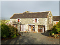
Nether Barr Steading
Six self-catering lodges converted from old farm buildings overlooking the Cree marshes. Cairnsmore of Fleet Image is obscured by cloud.
Image: © Oliver Dixon
Taken: 1 Jun 2015
0.04 miles
3
Nether Barr
Nether Barr Steading, a restaurant and holiday lodgings off the Wigtown road south of Newton Stewart.
Image: © Chris Newman
Taken: 2 Apr 2008
0.04 miles
4
Nether Barr Steading
A block of six self-catering lodges converted from old farm buildings overlooking the Cree marshes.
Image: © Oliver Dixon
Taken: 1 Jun 2015
0.05 miles
5
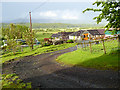
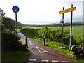
Nether Barr
Viewed north along the A714 towards the farm.
Image: © Andy Farrington
Taken: 12 Jul 2010
0.07 miles
6
Cycle path beside the A714
National Cycle Network 73 runs round the south-west of Scotland. South of Newton Stewart, it follows the A714 for about 2 km. To keep cyclists off the main road, a separate cycle path has been constructed; north of Nether Barr, this takes the form of a new path constructed behind the hedge line. (Google Streetview imagery of 2009 shows this path under construction).
Image: © Oliver Dixon
Taken: 1 Jun 2015
0.08 miles
7
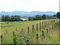
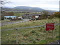
Nether Barr
View of the farm from the A714
Image: © Andy Farrington
Taken: 12 Jul 2010
0.08 miles
8
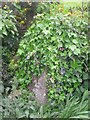
Old Milestone by the A714, The Nether Barr Steading, Penninghame parish
Milestone by the A714, in parish of Penninghame (Wigtownshire District), nearly opposite and North of the sign 'The Nether Barr Steading', hidden under ivy, Southwest side of road.
Surveyed
Milestone Society National ID: DG_NSWG01
Image: © Milestone Society
Taken: Unknown
0.09 miles
9
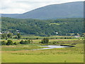
Cree Estuary
View across the estuary to the A75 as it runs down to Creetown
Image: © Andy Farrington
Taken: 12 Jul 2010
0.11 miles
10
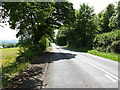
A714 Newton Stewart
View south of this road as it runs down to Wigtown
Image: © Andy Farrington
Taken: 12 Jul 2010
0.11 miles