IMAGES TAKEN NEAR TO
Glenluce, NEWTON STEWART, DG8 0PD
Introduction
This page details the photographs taken nearby to DG8 0PD by members of the Geograph project.
The Geograph project started in 2005 with the aim of publishing, organising and preserving representative images for every square kilometre of Great Britain, Ireland and the Isle of Man.

There are currently over 7.5m images from over14,400 individuals and you can help contribute to the project by visiting https://www.geograph.org.uk
Image Map
Images are licensed for reuse under creativecommons.org/licenses/by-sa/2.0
Notes
- Clicking on the map will re-center to the selected point.
- The higher the marker number, the further away the image location is from the centre of the postcode.
Image Listing (6 Images Found)
Images are licensed for reuse under creativecommons.org/licenses/by-sa/2.0
Image
Details
Distance
1
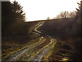
Artfield Farm
View south west to the back of the farm taken from the forestry track through the fell.
Image: © Andy Farrington
Taken: 31 Aug 2013
0.08 miles
2
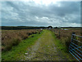
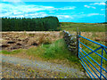
Track to Artfield Fell
Left is the access road to the wind turbines and right goes up to Artfield Farm and the forest.
Image: © Andy Farrington
Taken: 31 Aug 2013
0.09 miles
3
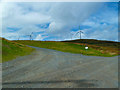
Green Top
Looking west to the Artfield Fell Wind Turbines.
Image: © Andy Farrington
Taken: 31 Aug 2013
0.11 miles
4
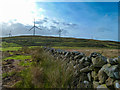
Craig-gork
View to the woodland form the forestry track by Artfield Farm.
Image: © Andy Farrington
Taken: 31 Aug 2013
0.13 miles
5
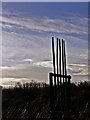
Firebeaters
For beating out forest fires.
Image: © David Baird
Taken: 6 Jan 2008
0.16 miles