IMAGES TAKEN NEAR TO
New Luce, NEWTON STEWART, DG8 0NB
Introduction
This page details the photographs taken nearby to DG8 0NB by members of the Geograph project.
The Geograph project started in 2005 with the aim of publishing, organising and preserving representative images for every square kilometre of Great Britain, Ireland and the Isle of Man.

There are currently over 7.5m images from over14,400 individuals and you can help contribute to the project by visiting https://www.geograph.org.uk
Image Map
Images are licensed for reuse under creativecommons.org/licenses/by-sa/2.0
Notes
- Clicking on the map will re-center to the selected point.
- The higher the marker number, the further away the image location is from the centre of the postcode.
Image Listing (6 Images Found)
Images are licensed for reuse under creativecommons.org/licenses/by-sa/2.0
Image
Details
Distance
1
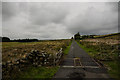
Cattle Grid
View north up this single track road that leads to Balmurrie Farm.
Image: © Andy Farrington
Taken: 20 Aug 2013
0.07 miles
2
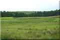
Grass field at Balmurrie
Rough grass fields near to the farm at Balmurrie. Low Plantation is the woodland in the distance.
Image: © Graham Robson
Taken: 24 Jun 2019
0.07 miles
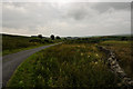
3
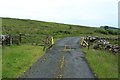
Cattle grid on the road to Balmurrie
A cattle grid on the minor road which provides the only road access to the isolated farm at Balmurrie. The southern Upland Way long distance path follows the road.
Image: © Graham Robson
Taken: 24 Jun 2019
0.09 miles
4
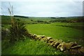
View near Dranigower
From the Southern Upland Way, looking across the valley where the Cross Water of Luce runs. Mainly sheep farming in the lower lying fields.
Image: © Graham Horn
Taken: 10 Jun 2002
0.10 miles
5
White Bar
Looking south along this single track road that runs down to New Luce.
Image: © Andy Farrington
Taken: 20 Aug 2013
0.14 miles
6
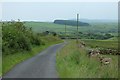
Minor road at Balmurrie
The minor road which climbs from Dranigower to Balmurrie. The Southern Upland Way follows this stretch of road.
Image: © Graham Robson
Taken: 24 Jun 2019
0.15 miles