IMAGES TAKEN NEAR TO
Auchenmalg, Glenluce, NEWTON STEWART, DG8 0JT
Introduction
This page details the photographs taken nearby to DG8 0JT by members of the Geograph project.
The Geograph project started in 2005 with the aim of publishing, organising and preserving representative images for every square kilometre of Great Britain, Ireland and the Isle of Man.

There are currently over 7.5m images from over14,400 individuals and you can help contribute to the project by visiting https://www.geograph.org.uk
Image Map
Images are licensed for reuse under creativecommons.org/licenses/by-sa/2.0
Notes
- Clicking on the map will re-center to the selected point.
- The higher the marker number, the further away the image location is from the centre of the postcode.
Image Listing (41 Images Found)
Images are licensed for reuse under creativecommons.org/licenses/by-sa/2.0
Image
Details
Distance
1
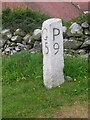
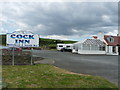
Old Milestone by the A747, Cock Inn, Old Luce Parish
By the A747, in parish of Old Luce (Wigtownshire District), at Cock Inn on bend, North side of pub.
Inscription reads:- : G / 5 : : P / 9 : (To Glenluce and Port William)
Surveyed
Milestone Society National ID: DG_PWGL09
Image: © Milestone Society
Taken: Unknown
0.00 miles
2
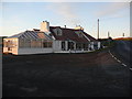
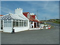
The Cock Inn at Auchenmalg
The pub sits at the side of the A747 in Auchenmalg and closes over the winter months.
Image: © Andy Farrington
Taken: 13 Dec 2010
0.01 miles
3
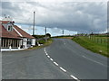
Road to Glenluce
Passing the Cock Inn on the left.
Image: © Billy McCrorie
Taken: 4 Jun 2012
0.01 miles
4
The Cock Inn at Auchenmalg
View of this pub on the coast by the A747 at Auchenmalg, currently open for business although it does close over the winter months.
Image: © Andy Farrington
Taken: 25 Oct 2011
0.01 miles
5
The Cock Inn
Entrance to the car park at the Inn.
Image: © Billy McCrorie
Taken: 4 Jun 2012
0.03 miles
6
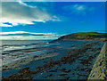
Auchenmalg Bay
Calm across the bay after recent storms looking towards the Mull of Sinniness to the right.
Image: © Andy Farrington
Taken: 9 Jan 2014
0.04 miles
7
Luce Bay Caravan Park
Looking along the coast and past the park from Auchenmalg.
Image: © Andy Farrington
Taken: 9 Jan 2014
0.06 miles
8
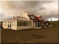
The Cock Inn
This is named on the '40s map. It is remote from any substantial village so presumably was there for travellers down the Machars coast. It is now conveniently close to a large caravan site.
Image: © David Medcalf
Taken: 16 Jul 2006
0.06 miles
9
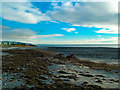
Beach in front of the Cock Inn
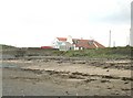
High tide lines dominate at the top of the beach. High walls separate the car park of the Cock Inn from the danger of high seas. Telegraph poles mark the line of the A747 as it takes a sharp turn inland.
Image: © Ann Cook
Taken: 18 Apr 2010
0.06 miles
10
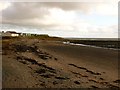
Auchenmalg
View along the shore line with Luce Bay Caravan Park to the left of the picture.
Image: © Andy Farrington
Taken: 25 Oct 2011
0.07 miles