IMAGES TAKEN NEAR TO
Auchenmalg, Glenluce, NEWTON STEWART, DG8 0JR
Introduction
This page details the photographs taken nearby to DG8 0JR by members of the Geograph project.
The Geograph project started in 2005 with the aim of publishing, organising and preserving representative images for every square kilometre of Great Britain, Ireland and the Isle of Man.

There are currently over 7.5m images from over14,400 individuals and you can help contribute to the project by visiting https://www.geograph.org.uk
Image Map
Images are licensed for reuse under creativecommons.org/licenses/by-sa/2.0
Notes
- Clicking on the map will re-center to the selected point.
- The higher the marker number, the further away the image location is from the centre of the postcode.
Image Listing (25 Images Found)
Images are licensed for reuse under creativecommons.org/licenses/by-sa/2.0
Image
Details
Distance
3
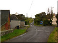
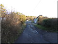
Auchenmalg
Auchenmalg consists of a few houses and farms, a village hall, telephone box and an excellent pub.
Image: © David Baird
Taken: 13 Oct 2007
0.03 miles
4
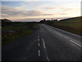
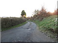
Auchenmalg
View along the A747 as it drops down into Auchenmalg. Luce Bay is on the horizon.
Image: © Andy Farrington
Taken: 13 Dec 2010
0.03 miles
5
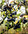
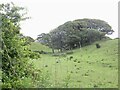
Sloes
The sloe is the fruit of the blackthorn and is the ancestor of the damson. They are very bitter but are excellent when used to make sloe gin
Image: © David Baird
Taken: 13 Oct 2007
0.04 miles