IMAGES TAKEN NEAR TO
Kirkcowan, NEWTON STEWART, DG8 0EQ
Introduction
This page details the photographs taken nearby to DG8 0EQ by members of the Geograph project.
The Geograph project started in 2005 with the aim of publishing, organising and preserving representative images for every square kilometre of Great Britain, Ireland and the Isle of Man.

There are currently over 7.5m images from over14,400 individuals and you can help contribute to the project by visiting https://www.geograph.org.uk
Image Map
Images are licensed for reuse under creativecommons.org/licenses/by-sa/2.0
Notes
- Clicking on the map will re-center to the selected point.
- The higher the marker number, the further away the image location is from the centre of the postcode.
Image Listing (12 Images Found)
Images are licensed for reuse under creativecommons.org/licenses/by-sa/2.0
Image
Details
Distance
1
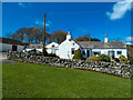
Barneight Farm
Also called Barnaight on older OS Mapping, on the slopes of Ardachie Fell.
Image: © Andy Farrington
Taken: 1 May 2013
0.02 miles
2
Barneight Farm
Also known as Barnaight on older mapping, the view here is of the back of the farm when walking off the fells.
Image: © Andy Farrington
Taken: 1 May 2013
0.03 miles
3
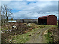
Track to Barneight
Farm track off the fell and down to the farm with Barneight Plantation to the sides.
Image: © Andy Farrington
Taken: 1 May 2013
0.10 miles
4
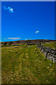
Track to the fell
Walking from Barneight Farm past a sheepfold centre of picture and out on to Ardachie Fell.
Image: © Andy Farrington
Taken: 1 May 2013
0.16 miles
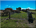
5
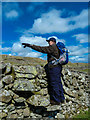
I see no Sheeps
My walking companion for the day Robin Cope, pointing out an access route for sheep into the sheepfold we found at the foot of Ardachie Fell, which is in the background. Showing here a good example of stone steps common to the area that are positioned in stane walls to give easy access over the wall.
Image: © Andy Farrington
Taken: 1 May 2013
0.21 miles
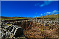
6

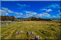
Sheepfold by Ardachie Fell
Found on the south slopes of the fell and still in use.
Image: © Andy Farrington
Taken: 1 May 2013
0.22 miles
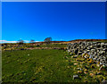
7
Stone Sheep Pen
Although overgrown in places still in use, to the west of Barneight Farm below Ardachie Fell.
Image: © Andy Farrington
Taken: 1 May 2013
0.22 miles
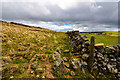
8
Sheepfold by Ardachie Fell
Looking across to Culvennan Fell and Fell End.
Image: © Andy Farrington
Taken: 1 May 2013
0.22 miles
9
Track from Barneight
A small track leads to this point at the edge of Ardachie Fell from Barneight Farm.
Image: © Andy Farrington
Taken: 1 May 2013
0.23 miles
10
Old Military Road
The route of the road leads to Ardachie Farm in this direction.
Image: © Andy Farrington
Taken: 1 May 2013
0.23 miles