IMAGES TAKEN NEAR TO
Main Street, CASTLE DOUGLAS, DG7 3YA
Introduction
This page details the photographs taken nearby to Main Street, DG7 3YA by members of the Geograph project.
The Geograph project started in 2005 with the aim of publishing, organising and preserving representative images for every square kilometre of Great Britain, Ireland and the Isle of Man.

There are currently over 7.5m images from over14,400 individuals and you can help contribute to the project by visiting https://www.geograph.org.uk
Image Map
Images are licensed for reuse under creativecommons.org/licenses/by-sa/2.0
Notes
- Clicking on the map will re-center to the selected point.
- The higher the marker number, the further away the image location is from the centre of the postcode.
Image Listing (25 Images Found)
Images are licensed for reuse under creativecommons.org/licenses/by-sa/2.0
Image
Details
Distance
1
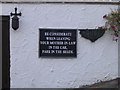
Wise advice
One of several notices in similar vein at the Laurie Arms in Haugh of Urr.
Image: © M J Richardson
Taken: 21 Sep 2007
0.01 miles
5
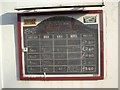
Guest Ales
Details on the guest ales available at The Laurie Arms Hotel.
Image: © Colin Kinnear
Taken: 16 Feb 2008
0.04 miles
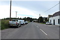
8
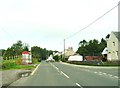
The bus stop in Haugh of Urr
Braeside is on the right.
Image: © Ann Cook
Taken: 15 Sep 2012
0.06 miles
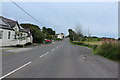
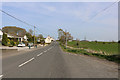
10
Main Street, Haugh of Urr
From the junction with Port Road and The Causey.
Image: © Richard Sutcliffe
Taken: 19 May 2017
0.11 miles