IMAGES TAKEN NEAR TO
Dalry, CASTLE DOUGLAS, DG7 3XS
Introduction
This page details the photographs taken nearby to DG7 3XS by members of the Geograph project.
The Geograph project started in 2005 with the aim of publishing, organising and preserving representative images for every square kilometre of Great Britain, Ireland and the Isle of Man.

There are currently over 7.5m images from over14,400 individuals and you can help contribute to the project by visiting https://www.geograph.org.uk
Image Map (Loading...)


Getting Data...Please wait
Leaflet Map data © OpenStreetMap
Images are licensed for reuse under creativecommons.org/licenses/by-sa/2.0
Notes
- Clicking on the map will re-center to the selected point.
- The higher the marker number, the further away the image location is from the centre of the postcode.
Image Listing (6 Images Found)
Images are licensed for reuse under creativecommons.org/licenses/by-sa/2.0
Image
Details
Distance
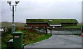
1
Green House
Offices for Natural Power
Image: © Darrin Antrobus
Taken: 3 Feb 2011
0.04 miles
2
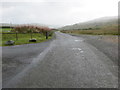
Road to A713 at the entrance to The Green House
Looking south-eastward.
Image: © Peter Wood
Taken: 12 Sep 2017
0.05 miles
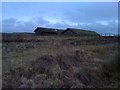
3
Offices, Low Pennyturn
This newly constructed turf roofed building are offices for a utility company. I'm not sure what the surveillance cameras are looking at. They appear to be directed up and down the dead end road.
Image: © Mick Garratt
Taken: 28 Oct 2006
0.09 miles
4
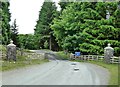
The Forrest Lodge lane
Looking back towards the A713.
Image: © David Purchase
Taken: 30 Oct 2018
0.15 miles
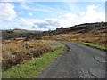
5
Road to Forrest Lodge
Looking east toward the Natural Power offices
Image: © Darrin Antrobus
Taken: 3 Feb 2011
0.16 miles
6
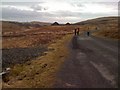
Forrest Estate Road
The start of Forrest Estate, where walkers are welcomed.
Image: © Mary and Angus Hogg
Taken: 18 Jun 2013
0.21 miles