IMAGES TAKEN NEAR TO
Dalry, CASTLE DOUGLAS, DG7 3UA
Introduction
This page details the photographs taken nearby to DG7 3UA by members of the Geograph project.
The Geograph project started in 2005 with the aim of publishing, organising and preserving representative images for every square kilometre of Great Britain, Ireland and the Isle of Man.

There are currently over 7.5m images from over14,400 individuals and you can help contribute to the project by visiting https://www.geograph.org.uk
Image Map
Images are licensed for reuse under creativecommons.org/licenses/by-sa/2.0
Notes
- Clicking on the map will re-center to the selected point.
- The higher the marker number, the further away the image location is from the centre of the postcode.
Image Listing (8 Images Found)
Images are licensed for reuse under creativecommons.org/licenses/by-sa/2.0
Image
Details
Distance
1
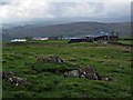
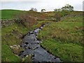
Nether Cleugh
Carsfad Loch Image, part of the Galloway Hydro-Electric scheme, in the middle distance. The Rhinns of Kells are on the skyline.
Image: © Oliver Dixon
Taken: 18 Oct 2006
0.09 miles
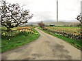
3
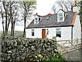
Cleugh Bridge on the B7000
Cleughbrae is the white building to the left of the road.
Image: © Ann Cook
Taken: 12 May 2013
0.14 miles
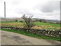
8
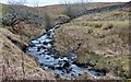
Stream near Cleughbrae
Seen from the B7000. This stream drains into Carsfad Loch, one of the series of lochs in the Galloway Hydro-Electric Scheme.
Image: © Oliver Dixon
Taken: 18 Oct 2006
0.22 miles