IMAGES TAKEN NEAR TO
Dalry, CASTLE DOUGLAS, DG7 3TU
Introduction
This page details the photographs taken nearby to DG7 3TU by members of the Geograph project.
The Geograph project started in 2005 with the aim of publishing, organising and preserving representative images for every square kilometre of Great Britain, Ireland and the Isle of Man.

There are currently over 7.5m images from over14,400 individuals and you can help contribute to the project by visiting https://www.geograph.org.uk
Image Map (19 Images)


Getting Data...Please wait
Leaflet Map data © OpenStreetMap
Images are licensed for reuse under creativecommons.org/licenses/by-sa/2.0
Notes
- Clicking on the map will re-center to the selected point.
- The higher the marker number, the further away the image location is from the centre of the postcode.
Image Listing (19 Images Found)
Images are licensed for reuse under creativecommons.org/licenses/by-sa/2.0
Image
Details
Distance
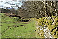
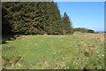
6
Southern Upland Way
With marker post.
Image: © Billy McCrorie
Taken: 16 Apr 2015
0.14 miles
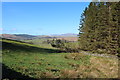
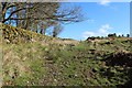
7
Southern Upland Way
With marker post.
Image: © Billy McCrorie
Taken: 16 Apr 2015
0.15 miles
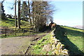
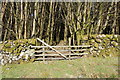
8
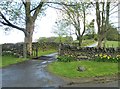
A cattle grid at the entrance to Creaganfois
"Creaganfois" is carved into a stone which is set low down in the wall, to the right of the gateway.
Image: © Ann Cook
Taken: 13 May 2013
0.16 miles
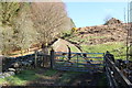
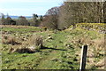
9
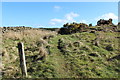
Southern Upland Way
With marker post.
Image: © Billy McCrorie
Taken: 16 Apr 2015
0.17 miles