IMAGES TAKEN NEAR TO
Carsphairn, CASTLE DOUGLAS, DG7 3TG
Introduction
This page details the photographs taken nearby to DG7 3TG by members of the Geograph project.
The Geograph project started in 2005 with the aim of publishing, organising and preserving representative images for every square kilometre of Great Britain, Ireland and the Isle of Man.

There are currently over 7.5m images from over14,400 individuals and you can help contribute to the project by visiting https://www.geograph.org.uk
Image Map (Loading...)


Getting Data...Please wait
Leaflet Map data © OpenStreetMap
Images are licensed for reuse under creativecommons.org/licenses/by-sa/2.0
Notes
- Clicking on the map will re-center to the selected point.
- The higher the marker number, the further away the image location is from the centre of the postcode.
Image Listing (9 Images Found)
Images are licensed for reuse under creativecommons.org/licenses/by-sa/2.0
Image
Details
Distance
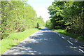
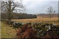
3
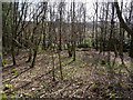
Lower Plantation
A well defended woodland beside the Water of Deugh.
Image: © Richard Webb
Taken: 19 Apr 2019
0.16 miles
5
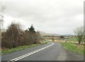
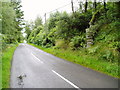
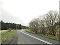
Double white lines on the A713
Liggat Bridge can be seen in the distance.
Image: © Ann Cook
Taken: 12 May 2013
0.17 miles
8
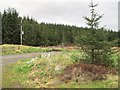
Plantation and moor at Andrew's Knowe
A new mansion has been built on Cumnock Knowes in a partly felled plantation.
Image: © Alan Reid
Taken: 16 Mar 2018
0.22 miles