IMAGES TAKEN NEAR TO
Carsphairn, CASTLE DOUGLAS, DG7 3TF
Introduction
This page details the photographs taken nearby to DG7 3TF by members of the Geograph project.
The Geograph project started in 2005 with the aim of publishing, organising and preserving representative images for every square kilometre of Great Britain, Ireland and the Isle of Man.

There are currently over 7.5m images from over14,400 individuals and you can help contribute to the project by visiting https://www.geograph.org.uk
Image Map
Images are licensed for reuse under creativecommons.org/licenses/by-sa/2.0
Notes
- Clicking on the map will re-center to the selected point.
- The higher the marker number, the further away the image location is from the centre of the postcode.
Image Listing (66 Images Found)
Images are licensed for reuse under creativecommons.org/licenses/by-sa/2.0
Image
Details
Distance
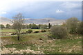
5
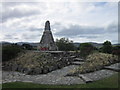
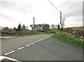
Road to Carsphairn
From the war memorial.
Image: © Billy McCrorie
Taken: 9 Jul 2012
0.07 miles
6
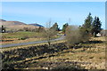
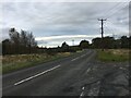
Grass Field and Bushes, Carsphairn
With view to the Rhinns of Kells Range.
Image: © Billy McCrorie
Taken: 13 May 2021
0.07 miles
7
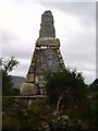
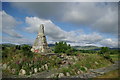
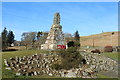
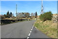
War Memorial.
This memorial is built of local stone and was unveiled in 1923 by Colonel William H Clark-Kennedy VC of Knockgray.
Image: © Bob Peace
Taken: 7 Aug 2007
0.09 miles