IMAGES TAKEN NEAR TO
Dundeugh, CASTLE DOUGLAS, DG7 3SX
Introduction
This page details the photographs taken nearby to Dundeugh, DG7 3SX by members of the Geograph project.
The Geograph project started in 2005 with the aim of publishing, organising and preserving representative images for every square kilometre of Great Britain, Ireland and the Isle of Man.

There are currently over 7.5m images from over14,400 individuals and you can help contribute to the project by visiting https://www.geograph.org.uk
Image Map (50 Images)


Getting Data...Please wait
Leaflet Map data © OpenStreetMap
Images are licensed for reuse under creativecommons.org/licenses/by-sa/2.0
Notes
- Clicking on the map will re-center to the selected point.
- The higher the marker number, the further away the image location is from the centre of the postcode.
Image Listing (50 Images Found)
Images are licensed for reuse under creativecommons.org/licenses/by-sa/2.0
Image
Details
Distance
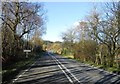
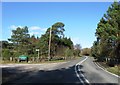
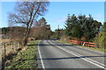
1
Road to St John's Town of Dalry at Dundeugh
Image: © Billy McCrorie
Taken: 15 Feb 2016
0.04 miles
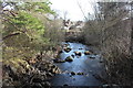
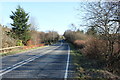
3
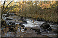
Polmaddy Burn
Taken just above where the Polmaddy conjoins with the Water of Deugh
Image: © Brian Joyce
Taken: 11 Dec 2005
0.05 miles