IMAGES TAKEN NEAR TO
Dalry, CASTLE DOUGLAS, DG7 3SU
Introduction
This page details the photographs taken nearby to DG7 3SU by members of the Geograph project.
The Geograph project started in 2005 with the aim of publishing, organising and preserving representative images for every square kilometre of Great Britain, Ireland and the Isle of Man.

There are currently over 7.5m images from over14,400 individuals and you can help contribute to the project by visiting https://www.geograph.org.uk
Image Map (Loading...)


Getting Data...Please wait
Leaflet Map data © OpenStreetMap
Images are licensed for reuse under creativecommons.org/licenses/by-sa/2.0
Notes
- Clicking on the map will re-center to the selected point.
- The higher the marker number, the further away the image location is from the centre of the postcode.
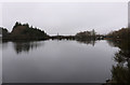
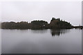
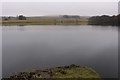
Image Listing (8 Images Found)
Images are licensed for reuse under creativecommons.org/licenses/by-sa/2.0
Image
Details
Distance
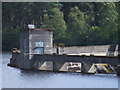
1
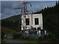
Carsfad Power Station
With Carsfad dam in the background. Completed in 1936 and built by the Galloway Water Power Co, Carsfad is part of the Galloway hydroelectric scheme.
Image: © Paul Hookway
Taken: 20 Aug 2006
0.04 miles
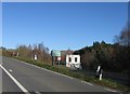
4
The entrance to Carsfad Power Station
The A713 is on the left.
Image: © Ann Cook
Taken: 12 May 2013
0.08 miles