IMAGES TAKEN NEAR TO
Dalry, CASTLE DOUGLAS, DG7 3SS
Introduction
This page details the photographs taken nearby to DG7 3SS by members of the Geograph project.
The Geograph project started in 2005 with the aim of publishing, organising and preserving representative images for every square kilometre of Great Britain, Ireland and the Isle of Man.

There are currently over 7.5m images from over14,400 individuals and you can help contribute to the project by visiting https://www.geograph.org.uk
Image Map (Loading...)


Getting Data...Please wait
Leaflet Map data © OpenStreetMap
Images are licensed for reuse under creativecommons.org/licenses/by-sa/2.0
Notes
- Clicking on the map will re-center to the selected point.
- The higher the marker number, the further away the image location is from the centre of the postcode.
Image Listing (16 Images Found)
Images are licensed for reuse under creativecommons.org/licenses/by-sa/2.0
Image
Details
Distance
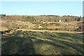
1
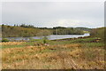
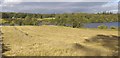
Earlstoun Loch.
A reservoir of water formed in the Water of Ken to generate Hydro Electricity.
Image: © Bob Peace
Taken: 4 Aug 2007
0.07 miles
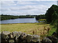
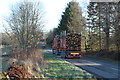
3
Earlstoun Loch
And Reservoir, view from the A713.
Image: © Billy McCrorie
Taken: 13 May 2021
0.12 miles
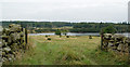
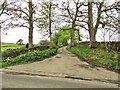
4

The A713 near Earlstoun Loch
Part of the loch can just be glimpsed on the left.
Image: © Ann Cook
Taken: 12 May 2013
0.13 miles
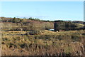
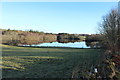
8
Earlstoun Loch
The north west end of Earlstoun Loch which is in fact a reservoir.
Image: © Colin Kinnear
Taken: 20 Jul 2020
0.18 miles