IMAGES TAKEN NEAR TO
Dalry, CASTLE DOUGLAS, DG7 3SR
Introduction
This page details the photographs taken nearby to DG7 3SR by members of the Geograph project.
The Geograph project started in 2005 with the aim of publishing, organising and preserving representative images for every square kilometre of Great Britain, Ireland and the Isle of Man.

There are currently over 7.5m images from over14,400 individuals and you can help contribute to the project by visiting https://www.geograph.org.uk
Image Map (Loading...)


Getting Data...Please wait
Leaflet Map data © OpenStreetMap
Images are licensed for reuse under creativecommons.org/licenses/by-sa/2.0
Notes
- Clicking on the map will re-center to the selected point.
- The higher the marker number, the further away the image location is from the centre of the postcode.
Image Listing (55 Images Found)
Images are licensed for reuse under creativecommons.org/licenses/by-sa/2.0
Image
Details
Distance
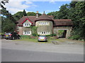
2

Gatehouse by the Water of Ken
This impressive gatehouse (too grand to call it a mere lodge) appears to serve an estate on the east bank of the Water of Ken.
Image: © Oliver Dixon
Taken: 13 Oct 2006
0.05 miles
5
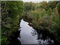
Water of Ken below Earlstoun Loch
From the bridge which carries the A713 Castle Douglas to Ayr road.
Image: © Oliver Dixon
Taken: 13 Oct 2006
0.07 miles
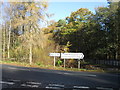
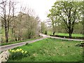
7
Earlstoun
View along the A762 by the power station looking towards the junction with the A713.
Image: © Andy Farrington
Taken: 8 Oct 2011
0.11 miles
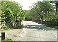
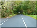
8
Road to Ayr
At Earlstoun Power Station.
Image: © Billy McCrorie
Taken: 10 Mar 2015
0.15 miles
9
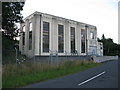
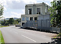
Earlstoun Power Station, Galloway Water Power Scheme
Dated 1936 on the building, Earlstoun Power Station is intended for unattended operation. The power station receives water from Earlstoun Loch and is a major component of Stage II of the Galloway Hydro-Electric Scheme. It is a Category B Listed Building. https://www.britishlistedbuildings.co.uk/200342027-earlstoun-power-station-kells#.WXPHAjGWw5s
Image: © G Laird
Taken: 20 Jul 2017
0.16 miles
10
Earlstoun Power Station
Built in 1936, as part of the Galloway hydro-electric power scheme https://en.wikipedia.org/wiki/Galloway_hydro-electric_power_scheme , Earlstoun is one of a network of dams and hydro-electric power generating stations which draw water from the Rivers Ken, Dee and Doon through reservoirs at Loch Doon, Kendoon, Carsfad, Clatteringshaws, and Tongland. The unusual modernist stations were designed by Scottish civil engineer, Sir Alexander Gibb.
Earlstoun Power Station is a Category B listed building (LB9725 http://portal.historicenvironment.scot/designation/LB9725 Historic Scotland).
Image: © David Dixon
Taken: 8 Aug 2016
0.16 miles