IMAGES TAKEN NEAR TO
Carsphairn, CASTLE DOUGLAS, DG7 3SN
Introduction
This page details the photographs taken nearby to DG7 3SN by members of the Geograph project.
The Geograph project started in 2005 with the aim of publishing, organising and preserving representative images for every square kilometre of Great Britain, Ireland and the Isle of Man.

There are currently over 7.5m images from over14,400 individuals and you can help contribute to the project by visiting https://www.geograph.org.uk
Image Map
Images are licensed for reuse under creativecommons.org/licenses/by-sa/2.0
Notes
- Clicking on the map will re-center to the selected point.
- The higher the marker number, the further away the image location is from the centre of the postcode.
Image Listing (5 Images Found)
Images are licensed for reuse under creativecommons.org/licenses/by-sa/2.0
Image
Details
Distance
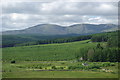
2
Braidenoch Lane
Looking upstream towards open moorland.
Image: © Mary and Angus Hogg
Taken: 18 Jun 2013
0.12 miles
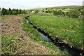
3
Braidenoch Lane
Looking downstream on a bright mid-June afternoon.
Image: © Mary and Angus Hogg
Taken: 18 Jun 2013
0.15 miles
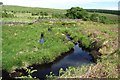
4
Birch Trees Near Braidenoch
These young birch trees are growing beside Braidenoch Lane.
Image: © Mary and Angus Hogg
Taken: 18 Jun 2013
0.19 miles
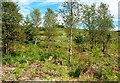
5
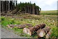
Forestry View
Trees of varying ages and stages near Braidenoch Lane.
Image: © Mary and Angus Hogg
Taken: 18 Jun 2013
0.20 miles