IMAGES TAKEN NEAR TO
New Galloway, CASTLE DOUGLAS, DG7 3SF
Introduction
This page details the photographs taken nearby to DG7 3SF by members of the Geograph project.
The Geograph project started in 2005 with the aim of publishing, organising and preserving representative images for every square kilometre of Great Britain, Ireland and the Isle of Man.

There are currently over 7.5m images from over14,400 individuals and you can help contribute to the project by visiting https://www.geograph.org.uk
Image Map (Loading...)


Getting Data...Please wait
Leaflet Map data © OpenStreetMap
Images are licensed for reuse under creativecommons.org/licenses/by-sa/2.0
Notes
- Clicking on the map will re-center to the selected point.
- The higher the marker number, the further away the image location is from the centre of the postcode.
Image Listing (33 Images Found)
Images are licensed for reuse under creativecommons.org/licenses/by-sa/2.0
Image
Details
Distance
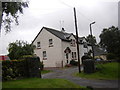
2
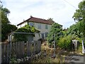
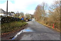
Houses at Glenlee
Boarded up housing at Glenlee.
Image: © Rab McMurdo
Taken: 11 Aug 2024
0.02 miles
4
Glenlee Power Station
Generating from Clatteringshaws Loch. A fair bit of the drainage of Galloway goes through the turbines here.
Image: © Richard Webb
Taken: 19 Jan 2020
0.09 miles
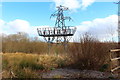
9
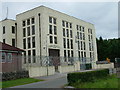
Glenlee Power Station
The chief station of the Galloway Hydro Scheme, from where all the other power stations are controlled.
Image: © Paul Hookway
Taken: 23 Jul 2005
0.13 miles
