IMAGES TAKEN NEAR TO
New Galloway, CASTLE DOUGLAS, DG7 3SA
Introduction
This page details the photographs taken nearby to DG7 3SA by members of the Geograph project.
The Geograph project started in 2005 with the aim of publishing, organising and preserving representative images for every square kilometre of Great Britain, Ireland and the Isle of Man.

There are currently over 7.5m images from over14,400 individuals and you can help contribute to the project by visiting https://www.geograph.org.uk
Image Map (Loading...)


Getting Data...Please wait
Leaflet Map data © OpenStreetMap
Images are licensed for reuse under creativecommons.org/licenses/by-sa/2.0
Notes
- Clicking on the map will re-center to the selected point.
- The higher the marker number, the further away the image location is from the centre of the postcode.
Image Listing (120 Images Found)
Images are licensed for reuse under creativecommons.org/licenses/by-sa/2.0
Image
Details
Distance
2
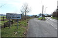
Farmland at Mains of Kenmure
With view of Ken Bridge in the centre.
Image: © Billy McCrorie
Taken: 11 Mar 2014
0.04 miles
3
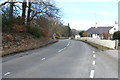
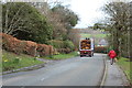
Entering New Galloway
Town centre road is on the right the one on the left is to free parking.
Image: © Billy McCrorie
Taken: 11 Mar 2014
0.05 miles
7
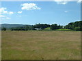
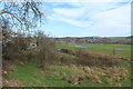
Farmland near New Galloway
The town is just beyond the wooded hill. Looking south west.
Image: © David Medcalf
Taken: 15 Jul 2006
0.11 miles
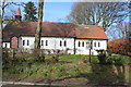
9
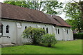
St Margaret's Episcopal Church, New Galloway
On Kenbridge Road.
Image: © Billy McCrorie
Taken: 14 Jun 2021
0.12 miles
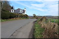
10
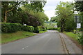
Kenbridge Road, New Galloway
Leading to the A713 Ayr to Castle Douglas Road.
Image: © Billy McCrorie
Taken: 14 Jun 2021
0.12 miles