IMAGES TAKEN NEAR TO
Balmaclellan, CASTLE DOUGLAS, DG7 3QN
Introduction
This page details the photographs taken nearby to DG7 3QN by members of the Geograph project.
The Geograph project started in 2005 with the aim of publishing, organising and preserving representative images for every square kilometre of Great Britain, Ireland and the Isle of Man.

There are currently over 7.5m images from over14,400 individuals and you can help contribute to the project by visiting https://www.geograph.org.uk
Image Map (Loading...)


Getting Data...Please wait
Leaflet Map data © OpenStreetMap
Images are licensed for reuse under creativecommons.org/licenses/by-sa/2.0
Notes
- Clicking on the map will re-center to the selected point.
- The higher the marker number, the further away the image location is from the centre of the postcode.
Image Listing (4 Images Found)
Images are licensed for reuse under creativecommons.org/licenses/by-sa/2.0
Image
Details
Distance
1
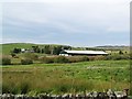
Large shed at Bartaggart
When the 1st Ordnance Survey was carried out Bartaggart was known as Redhill. http://maps.nls.uk/os/6inch/view/?sid=74427637&zoom=7&lat=9580.92785&lon=11074.5&layers=B
Image: © James Bell
Taken: 6 Sep 2010
0.18 miles
2
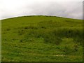
Bartaggart Hill
Looking round the shoulder of Bartaggart Hill towards Brighouse farm.
Image: © David Baird
Taken: 2 Jun 2007
0.18 miles