IMAGES TAKEN NEAR TO
Balmaclellan, CASTLE DOUGLAS, DG7 3PX
Introduction
This page details the photographs taken nearby to DG7 3PX by members of the Geograph project.
The Geograph project started in 2005 with the aim of publishing, organising and preserving representative images for every square kilometre of Great Britain, Ireland and the Isle of Man.

There are currently over 7.5m images from over14,400 individuals and you can help contribute to the project by visiting https://www.geograph.org.uk
Image Map (Loading...)


Getting Data...Please wait
Leaflet Map data © OpenStreetMap
Images are licensed for reuse under creativecommons.org/licenses/by-sa/2.0
Notes
- Clicking on the map will re-center to the selected point.
- The higher the marker number, the further away the image location is from the centre of the postcode.
Image Listing (7 Images Found)
Images are licensed for reuse under creativecommons.org/licenses/by-sa/2.0
Image
Details
Distance
2
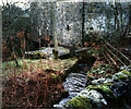
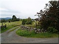
Ironmacannie
The old watermill was renovated by some old friends in the 1990s. Although I think it is now holiday cottages, all of the original gearing is preserved and displayed inside
Image: © Alison Covey
Taken: 24 Feb 2007
0.07 miles
3
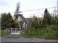
Old School, Ironmacannie
Former Ironmacannie School and school house, now a private residence.
Image: © Chris Newman
Taken: 23 Mar 2008
0.08 miles
6
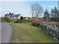
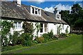
Cottage on the road across Shawknowes Moor
Image: © Richard Law
Taken: 24 Feb 2013
0.21 miles
7
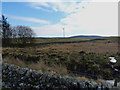
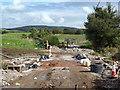
A wind turbine east of Shirmers Moss
A domestic, rather than a commercial, installation.
Image: © Richard Law
Taken: 24 Feb 2013
0.21 miles