IMAGES TAKEN NEAR TO
Hardgate, CASTLE DOUGLAS, DG7 3LD
Introduction
This page details the photographs taken nearby to DG7 3LD by members of the Geograph project.
The Geograph project started in 2005 with the aim of publishing, organising and preserving representative images for every square kilometre of Great Britain, Ireland and the Isle of Man.

There are currently over 7.5m images from over14,400 individuals and you can help contribute to the project by visiting https://www.geograph.org.uk
Image Map
Images are licensed for reuse under creativecommons.org/licenses/by-sa/2.0
Notes
- Clicking on the map will re-center to the selected point.
- The higher the marker number, the further away the image location is from the centre of the postcode.
Image Listing (12 Images Found)
Images are licensed for reuse under creativecommons.org/licenses/by-sa/2.0
Image
Details
Distance
3
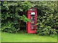
Hardgate Telephone Box
The telephone box in Hardgate, hidden away in the local undergrowth.
Image: © Colin Kinnear
Taken: 3 Aug 2008
0.08 miles
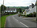
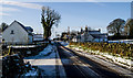
5
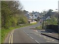
Hardgate
Slogging over the shoulder of Park Hill which is wooded and an obvious lovely resource for the pupils and staff of the primary school to the right.
Image: © Richard Webb
Taken: 22 Apr 2019
0.13 miles
8
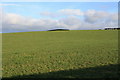
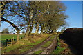
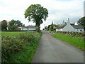
Good grazing at Three Merkland
Good grazing land close to Three Merkland farm.
Image: © Colin Kinnear
Taken: 9 Nov 2010
0.16 miles
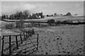
9
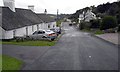
Hardgate again
Hardgate, with The Corse on the left a recent addition.It looks like a hobby holding with very pampered sheep.
Image: © Hugh Close
Taken: 26 Jan 2013
0.17 miles