IMAGES TAKEN NEAR TO
CASTLE DOUGLAS, DG7 3JT
Introduction
This page details the photographs taken nearby to DG7 3JT by members of the Geograph project.
The Geograph project started in 2005 with the aim of publishing, organising and preserving representative images for every square kilometre of Great Britain, Ireland and the Isle of Man.

There are currently over 7.5m images from over14,400 individuals and you can help contribute to the project by visiting https://www.geograph.org.uk
Image Map (Loading...)


Getting Data...Please wait
Leaflet Map data © OpenStreetMap
Images are licensed for reuse under creativecommons.org/licenses/by-sa/2.0
Notes
- Clicking on the map will re-center to the selected point.
- The higher the marker number, the further away the image location is from the centre of the postcode.
Image Listing (6 Images Found)
Images are licensed for reuse under creativecommons.org/licenses/by-sa/2.0
Image
Details
Distance
1
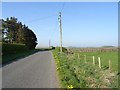
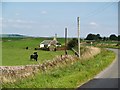
Old Military Road, Hopehead
If you look at the 2009 Streetview image, there was an Openreach engineer up the telegraph pole.
This was one of Caulfeild's roads running from the English border to Portpatrick.
Image: © Richard Webb
Taken: 22 Apr 2019
0.03 miles
2
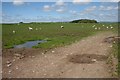
Field beside the old military road
Sheep and lambs grazing.
Image: © Richard Sutcliffe
Taken: 14 May 2018
0.10 miles
3
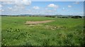
Field beside the old military road
Image: © Richard Sutcliffe
Taken: 14 May 2018
0.14 miles
4
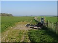
Grassland by Corbieton
Farmland north of the Old Military Road.
Image: © Richard Webb
Taken: 22 Apr 2019
0.18 miles
5
Old Military Road towards Blackerne Cottages.
Image: © James Bell
Taken: 5 Sep 2010
0.25 miles
6
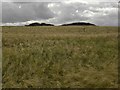
Cornfields
Looking across cornfields to a small wood.
Image: © Colin Kinnear
Taken: 25 Jun 2008
0.25 miles