IMAGES TAKEN NEAR TO
CASTLE DOUGLAS, DG7 3JJ
Introduction
This page details the photographs taken nearby to DG7 3JJ by members of the Geograph project.
The Geograph project started in 2005 with the aim of publishing, organising and preserving representative images for every square kilometre of Great Britain, Ireland and the Isle of Man.

There are currently over 7.5m images from over14,400 individuals and you can help contribute to the project by visiting https://www.geograph.org.uk
Image Map (Loading...)


Getting Data...Please wait
Leaflet Map data © OpenStreetMap
Images are licensed for reuse under creativecommons.org/licenses/by-sa/2.0
Notes
- Clicking on the map will re-center to the selected point.
- The higher the marker number, the further away the image location is from the centre of the postcode.
Image Listing (2 Images Found)
Images are licensed for reuse under creativecommons.org/licenses/by-sa/2.0
Image
Details
Distance
1
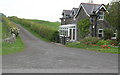
Lodge house & minor road to Corbieton House
Taken from Old Military Road
Image: © John Whelan
Taken: 24 May 2007
0.04 miles
2
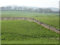
Lumpy field by Corbieton
I have just noticed a second red kite on the right. I can only remember seeing one at the time.
Image: © Richard Webb
Taken: 22 Apr 2019
0.07 miles