IMAGES TAKEN NEAR TO
Victoria Street, CASTLE DOUGLAS, DG7 3HQ
Introduction
This page details the photographs taken nearby to Victoria Street, DG7 3HQ by members of the Geograph project.
The Geograph project started in 2005 with the aim of publishing, organising and preserving representative images for every square kilometre of Great Britain, Ireland and the Isle of Man.

There are currently over 7.5m images from over14,400 individuals and you can help contribute to the project by visiting https://www.geograph.org.uk
Image Map (Loading...)


Getting Data...Please wait
Leaflet Map data © OpenStreetMap
Images are licensed for reuse under creativecommons.org/licenses/by-sa/2.0
Notes
- Clicking on the map will re-center to the selected point.
- The higher the marker number, the further away the image location is from the centre of the postcode.
Image Listing (20 Images Found)
Images are licensed for reuse under creativecommons.org/licenses/by-sa/2.0
Image
Details
Distance
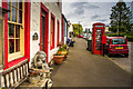
1
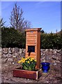
Waterpump 2002
The village waterpump renovated in 2002.
Image: © Colin Kinnear
Taken: 17 Mar 2009
0.03 miles
2
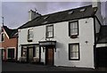
Crown Hotel
The Crown Hotel, now closed down.
Image: © Colin Kinnear
Taken: 24 Feb 2008
0.04 miles
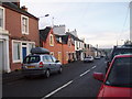
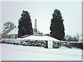
6
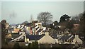
Kirkpatrick Durham - January 2007
Looking towards the centre of Kirkpatrick Durham from Knockfad Hill.
Image: © Stuart Cowan
Taken: 25 Jan 2007
0.10 miles
7
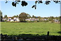
Kirkpatrick Durham Village
From the church grounds.
Image: © Billy McCrorie
Taken: 2 Oct 2019
0.11 miles
8
War Memorial - Saint David Street
The War Memorial is located next to the forge burn in Saint David Street.
Image: © Stuart Cowan
Taken: 8 Feb 2009
0.11 miles
9
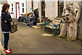
Art appreciation
A 'Spring Fling' visitor has an encounter
Image: © Hugh Close
Taken: 24 May 2014
0.13 miles