IMAGES TAKEN NEAR TO
CASTLE DOUGLAS, DG7 3ES
Introduction
This page details the photographs taken nearby to DG7 3ES by members of the Geograph project.
The Geograph project started in 2005 with the aim of publishing, organising and preserving representative images for every square kilometre of Great Britain, Ireland and the Isle of Man.

There are currently over 7.5m images from over14,400 individuals and you can help contribute to the project by visiting https://www.geograph.org.uk
Image Map (Loading...)


Getting Data...Please wait
Leaflet Map data © OpenStreetMap
Images are licensed for reuse under creativecommons.org/licenses/by-sa/2.0
Notes
- Clicking on the map will re-center to the selected point.
- The higher the marker number, the further away the image location is from the centre of the postcode.
Image Listing (9 Images Found)
Images are licensed for reuse under creativecommons.org/licenses/by-sa/2.0
Image
Details
Distance


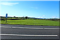
6
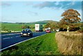
The A75 Near Castle Douglas
The busy A75, looking in the Dumfries direction on a blustery late-October afternoon.
Image: © Mary and Angus Hogg
Taken: 29 Oct 2013
0.13 miles
7
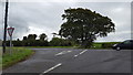
Road junction
Minor road joining the busy A75.
Image: © Peter Mackenzie
Taken: 6 Sep 2018
0.13 miles
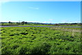
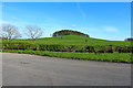
9
Farmland near Mollance
Over the A75.
Image: © Billy McCrorie
Taken: 24 Apr 2014
0.18 miles