IMAGES TAKEN NEAR TO
Garden Hill Road, CASTLE DOUGLAS, DG7 3EE
Introduction
This page details the photographs taken nearby to Garden Hill Road, DG7 3EE by members of the Geograph project.
The Geograph project started in 2005 with the aim of publishing, organising and preserving representative images for every square kilometre of Great Britain, Ireland and the Isle of Man.

There are currently over 7.5m images from over14,400 individuals and you can help contribute to the project by visiting https://www.geograph.org.uk
Image Map
Images are licensed for reuse under creativecommons.org/licenses/by-sa/2.0
Notes
- Clicking on the map will re-center to the selected point.
- The higher the marker number, the further away the image location is from the centre of the postcode.
Image Listing (8 Images Found)
Images are licensed for reuse under creativecommons.org/licenses/by-sa/2.0
Image
Details
Distance
1
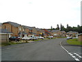
New housing near Garden Hill, Castle Douglas
This street doesn't appear on the maps yet.
Image: © Darrin Antrobus
Taken: 2 Jul 2007
0.06 miles
2
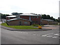
Garden Hill Primary Care Centre
Sunday morning at the new, unpretentious but efficient Primary Care Centre for the Castle Douglas area.
Image: © Chris Newman
Taken: 8 Jun 2008
0.08 miles
3
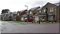
New Housing
New housing near Castle Douglas.
Image: © Colin Kinnear
Taken: 14 Jul 2008
0.09 miles
4
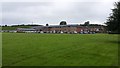
Looking towards the Health Centre
The new Health Centre sits in large grounds on the outskirt of the town.
Image: © Peter Mackenzie
Taken: 22 Aug 2017
0.09 miles
5
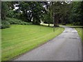
Urr Valley Hotel Driveway
The well tended driveway leading to the Urr Valley hotel.
Image: © Colin Kinnear
Taken: 25 Jun 2008
0.14 miles
6
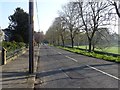
Ernespie Road
The A745 leaving Castle Douglas.
Image: © Richard Webb
Taken: 22 Apr 2019
0.19 miles
7
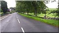
Leaving town
This is the route out of Castle Douglas towards the A75 and on to Dumfries.
Image: © Peter Mackenzie
Taken: 22 Aug 2017
0.20 miles
8
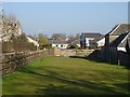
Gap on Ernespie Road
A gap in the row of houses, beyond Rob Place.
Image: © Richard Webb
Taken: 22 Apr 2019
0.22 miles