IMAGES TAKEN NEAR TO
Corsock, CASTLE DOUGLAS, DG7 3DU
Introduction
This page details the photographs taken nearby to DG7 3DU by members of the Geograph project.
The Geograph project started in 2005 with the aim of publishing, organising and preserving representative images for every square kilometre of Great Britain, Ireland and the Isle of Man.

There are currently over 7.5m images from over14,400 individuals and you can help contribute to the project by visiting https://www.geograph.org.uk
Image Map
Images are licensed for reuse under creativecommons.org/licenses/by-sa/2.0
Notes
- Clicking on the map will re-center to the selected point.
- The higher the marker number, the further away the image location is from the centre of the postcode.
Image Listing (3 Images Found)
Images are licensed for reuse under creativecommons.org/licenses/by-sa/2.0
Image
Details
Distance
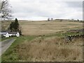
1
Nether Glaisters
View north at Nether Glaisters, a farm in the Upper Urr Valley on the Corsock Bridge to Glaisters road.
Image: © Chris Newman
Taken: 9 Mar 2008
0.01 miles
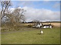
2
Yellow road, Nether Glaisters
A good road to visit if you are a pothole enthusiast.
Image: © Richard Webb
Taken: 3 Apr 2022
0.05 miles