IMAGES TAKEN NEAR TO
Corsock, CASTLE DOUGLAS, DG7 3DN
Introduction
This page details the photographs taken nearby to DG7 3DN by members of the Geograph project.
The Geograph project started in 2005 with the aim of publishing, organising and preserving representative images for every square kilometre of Great Britain, Ireland and the Isle of Man.

There are currently over 7.5m images from over14,400 individuals and you can help contribute to the project by visiting https://www.geograph.org.uk
Image Map
Images are licensed for reuse under creativecommons.org/licenses/by-sa/2.0
Notes
- Clicking on the map will re-center to the selected point.
- The higher the marker number, the further away the image location is from the centre of the postcode.
Image Listing (11 Images Found)
Images are licensed for reuse under creativecommons.org/licenses/by-sa/2.0
Image
Details
Distance
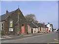
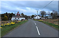
2
Corsock village hall from the Loch Urr road
Image: © Peter Bond
Taken: 8 Aug 2010
0.02 miles
3
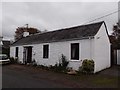
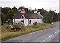
Former Tollhouse by the A712, Corsock
Toll House by the A712, in parish of Corsock (Dumfries and Galloway District), Rosevale, Corsock, DG7 3DW.
Surveyed
Milestone Society National ID: DG.COR
Image: © Milestone Society
Taken: Unknown
0.06 miles
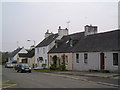
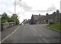
4
Corsock village from Crogo Mains road end
Image: © Simon Brooke
Taken: 13 Mar 2007
0.06 miles
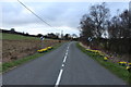
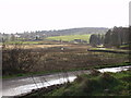
5
The western approach to Corsock
The A712 Dumfries-Newton Stewart Rd. approaching Corsock
Image: © Bob Peace
Taken: 19 Sep 2011
0.09 miles