IMAGES TAKEN NEAR TO
Kilquhanity, CASTLE DOUGLAS, DG7 3DB
Introduction
This page details the photographs taken nearby to DG7 3DB by members of the Geograph project.
The Geograph project started in 2005 with the aim of publishing, organising and preserving representative images for every square kilometre of Great Britain, Ireland and the Isle of Man.

There are currently over 7.5m images from over14,400 individuals and you can help contribute to the project by visiting https://www.geograph.org.uk
Image Map (Loading...)


Getting Data...Please wait
Leaflet Map data © OpenStreetMap
Images are licensed for reuse under creativecommons.org/licenses/by-sa/2.0
Notes
- Clicking on the map will re-center to the selected point.
- The higher the marker number, the further away the image location is from the centre of the postcode.
Image Listing (6 Images Found)
Images are licensed for reuse under creativecommons.org/licenses/by-sa/2.0
Image
Details
Distance
1
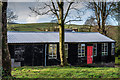
Kilquhanity
Kilquhanity School has now become Kilquhanity children's village
Image: © Hugh Close
Taken: 16 Dec 2013
0.01 miles
3
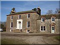
Kilquhanity House
Kilquhanity (1820) is a Classical mansion built by Walter Newall. A ‘free school’ from 1940 to 1997 – it has been refurbished and due to be fully open again as a school in 2009.
Image: © Chris Newman
Taken: 13 Feb 2008
0.04 miles
4
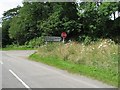
The road to Kirkpatrick Durham
Road signs pointing the way to Kirkpatrick Durham and Springholm
Image: © David Robertson
Taken: 4 Aug 2012
0.05 miles
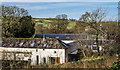
5

At Kilquhanity Farm
Looking west near to Kilquhanity Farm.
Image: © Peter Mackenzie
Taken: 6 Sep 2018
0.13 miles
6
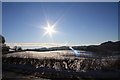
Winter Sun
Low winter sun over snow covered grazing land.
Image: © Colin Kinnear
Taken: 21 Dec 2010
0.14 miles