IMAGES TAKEN NEAR TO
Templand, CASTLE DOUGLAS, DG7 3BF
Introduction
This page details the photographs taken nearby to Templand, DG7 3BF by members of the Geograph project.
The Geograph project started in 2005 with the aim of publishing, organising and preserving representative images for every square kilometre of Great Britain, Ireland and the Isle of Man.

There are currently over 7.5m images from over14,400 individuals and you can help contribute to the project by visiting https://www.geograph.org.uk
Image Map (44 Images)


Getting Data...Please wait
Leaflet Map data © OpenStreetMap
Images are licensed for reuse under creativecommons.org/licenses/by-sa/2.0
Notes
- Clicking on the map will re-center to the selected point.
- The higher the marker number, the further away the image location is from the centre of the postcode.
Image Listing (44 Images Found)
Images are licensed for reuse under creativecommons.org/licenses/by-sa/2.0
Image
Details
Distance
1
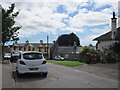
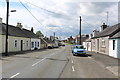
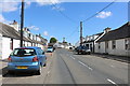
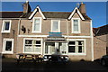
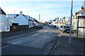
Main Street, Crossmichael
The Thistle Inn is part of this block of buildings on the Main Street.
Image: © Mary and Angus Hogg
Taken: 19 Sep 2016
0.10 miles
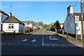
8
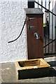
Crossmichael Village pump
The pump is on the southwest side of the A713 and was reinstated by village parishioners in 1994.
Image: © Walter Baxter
Taken: 24 Jul 2011
0.11 miles